Showing posts with label Georges River. Show all posts

Monday, 4 September 2023

MILESTONE: Alfords Point Bridge turns 50 (1973) - Opening

Last week, I posted an entry relating to the construction of the Alfords Point Bridge. This week will focus on the opening of the bridge in 1973.

By February 1973, the span of the bridge had been built, and it was anticipated that the bridge would be open to traffic in June of that year. The photo below was taken at the northern approach to the bridge at Padstow Heights, looking south. Note the footings already in place for the future duplication of the bridge in 2008. 

Alfords Point Bridge February 28 1973 The Leader 5 

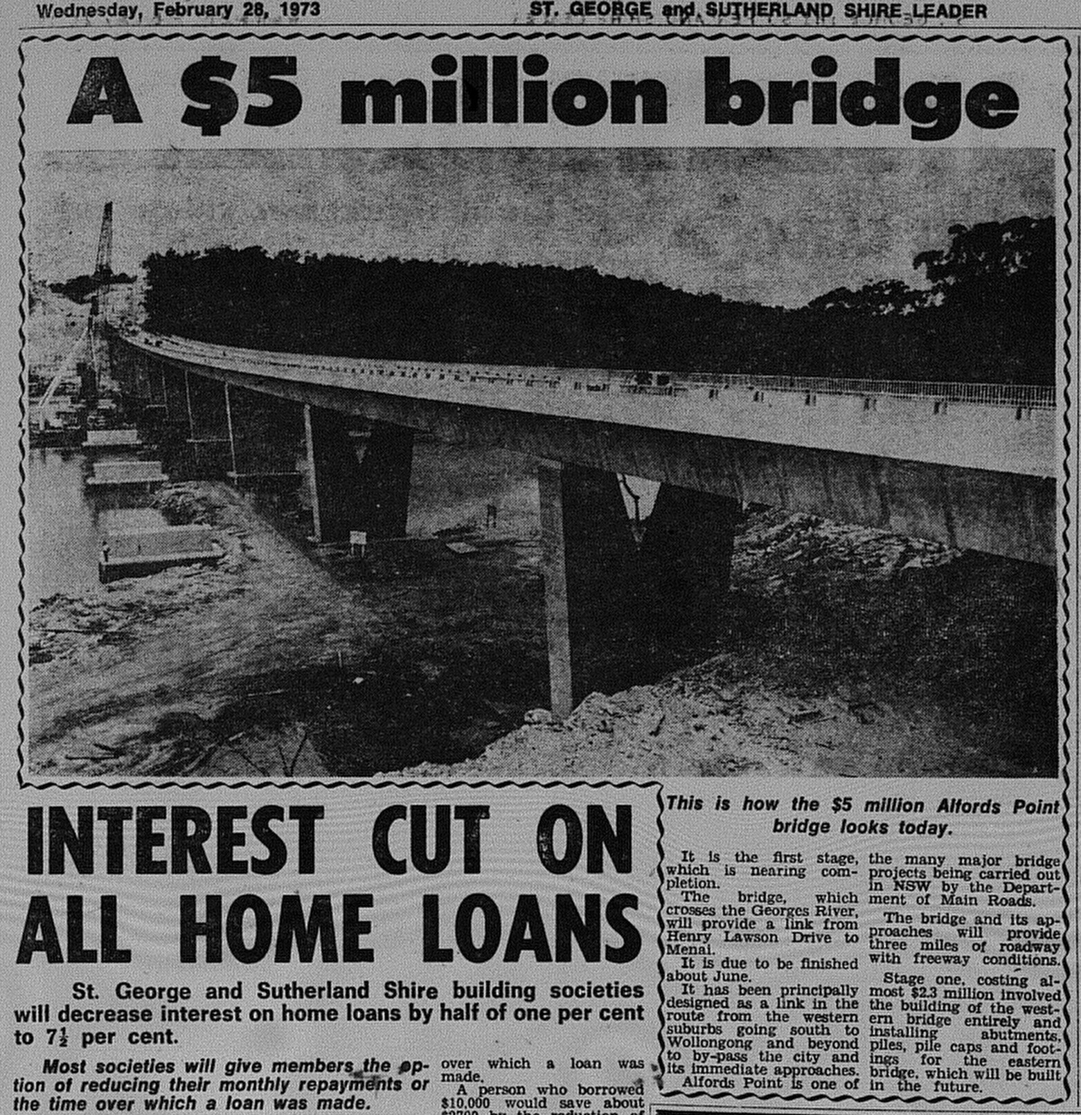
Source: Anon. 1973. "A $5 million bridge". The St George and Sutherland Shire Leader, February 28: 5. 

It was announced in June that the bridge would open in September. The Lugarno Ferry, which operated downstream linking Lugarno and Illawong, would continue for "some time", before running its last service the following year. 

Alfords Point Bridge August 1 1973 The Leader 11 

Source: Anon. 1973. "New bridge to open soon". The St George and Sutherland Shire Leader, August 1: 11. 

On 7 September 1973, the Alfords Point Bridge was officially opened to traffic by NSW Premier Sir Robert Askin. 2000 people were reported to have attended the opening ceremony, which included an opportunity for the public to walk across the bridge before opening to traffic. The final cost of construction was approximately $5 million. 

Below is coverage from The St George and Sutherland Shire Leader from September 12 1973.

Alfords Point Bridge September 12 1973 The Leader 1

Source: Anon. 1973. "Road snarl ease: Bridge skirts trouble sports". The St George and Sutherland Shire Leader, September 12: 1.

The bridge, when opened, initially carried two lanes of traffic (1 lane each way). This was increased to three lanes with a tidal flow arrangement in place.

Duplication of the bridge occurred in the 2000s. Construction of the new bridge commenced in 2007 and was opened to traffic in 2008. The original bridge reverted to two lanes and carried northbound traffic only, while the new bridge carries two lanes of southbound traffic.

Related Entry

MILESTONE: Alfords Point Bridge turns 50 (1973) - Proposals and construction

Monday, 28 August 2023

MILESTONE: Alfords Point Bridge turns 50 (1973) - Proposals and construction

This year, Alfords Point Bridge turns 50. The three-lane bridge was opened to traffic on 7 September 1973, while the second bridge was opened to traffic as part of its duplication in 2008.

Next week will focus on its opening, but this week, I will share some newspaper features relating to planning and construction. 

The St George and Sutherland Leader in 1961 reported that Menai residents were prepared to fund the construction of a bridge at Lugarno to link the then semi-rural suburb with the rest of Sydney.

Alfords Point Bridge November 16 1961 The Leader 14

Source: Anon. 1961. "Menai folk suggest levy for bridge". The St George and Sutherland Shire Leader, November 16: 14. 

In 1966, it was reported in The Sydney Morning Herald that the government intended to build a new bridge between Padstow Heights and Alfords Point. The location on the Georges River was selected because it was regarded as located halfway between the Milperra Bridge and Tom Ugly's Bridge. It was intended that contracts would be issued by mid-1968.

Alfords Point Bridge October 7 1966 SMH 6

Source: Anon. "New bridge promised". The Sydney Morning Herald, October 7: 6. 

At the end of 1969, it was announced that tenders would be called to build the new bridge as it was deemed a "high priority" in the Department of Main Roads building program. Apart from providing a third bridge to connect the Sutherland Shire with the St George region, it was to be built as part of a "bypass" or arterial road that would connect Heathcote and Hornsby (known today as the A6).

Alfords Point Bridge announcement 1969

Source: Anon. 1969. "Bridge will connect by-pass". The St George and Sutherland Shire Leader, December 3: 1.  

By February 1970, it was announced that work would start "almost immediately". In November 1970, it was announced that John Holland was the successful tender to build the bridge at an estimated $2.3 million, with a projected completion date of mid-1973. 

Alfords Point Bridge February 25 1970 the leader 1 (2)

Source: Anon. 1970. "Fast north-south: Early Start For Flyover". The St George and Sutherland Shire, February 25: 1. 

Below is an article from The St George and Sutherland Shire Leader reporting on the progress of construction in 1972.

Alfords Point Bridge February 9 1972 The Leader 18

Source: Anon. 1972. "Vital North-South Link Stays on Schedule". The St George and Sutherland Shire Leader, February 9: 18.

A progress report from July 1972 (below) contains a photo on construction of the bridge plus the announcement that John Holland was also to build the bridge connecting the bridge with Davies Street, Padstow.

Alfords Point Bridge July 12 1972 the Leader 15

Source: Anon. 1972. "Second bridge will speed Menai's traffic". The St George and Sutherland Shire Leader, July 12: 15. 

Finally, a photo feature from early 1973 which was published in The Daily Telegraph.

  Alfords Point Bridge February 8 1973 Daily Telegraph 24

Source: Anon. 1973. "Forging a new link...". The Daily Telegraph, February 8: 24.  

Monday, 10 October 2022

1985: Old Como Bridge becomes a footbridge and cycleway

The Old Como Bridge spanned the Georges River between Oatley and Como. It was a single track railway bridge that served the Illawarra and South Coast Railway Lines from 1885 until 1972, when a modern two track bridge was completed next to the original bridge. In 1985, the old bridge was reborn as a footbridge and a cycleway. It was offically opened on 16 December 1985 by Federal MP's Gary Punch (ALP, Barton) and Robert Tickner (ALP, Hughes).

  Como Bridge Walkway December 16 1985 daily telegraph 7

Source. Anon. 1985. "Spokes men bridge river gap". The Daily Telegraph, December 16: 7. 

Monday, 28 May 2018

1987: The rumour of the demise of Tom Uglys Bridge

In 1987, The three lane (can be expanded to four lanes)  Georges River Bridge was completed running parallel to Tom Uglys Bridge on the Georges River between Blakehurst and Sylvania,


Source: Anon. 1987. "Tom Uglys: It's Staying". The St George and Sutherland Shire Leader, July 28: 1.  

Just months prior to its opening, The Sun reported that the Department of Main Roads (DMR) was considering pulling the bridge down citing structural concerns. The DMR responded by stating that refurbishment works would occur after the opening of Georges River Bridge. The DMR followed through on the refurbishment work.

The idea of the Tom Ugly's Bridge being demolished was never going to be valid as the Georges River Bridge was built to complement the original bridge and remove the bottle necks on the Princes Highway on either side of the river.

Maintenance works on the bridge is a daily part of life. As a local it appears that as one project ends, the other ends.

For the record, there was restoration work in the 2000's to address structural issues. Also it is listed on the NSW Heritage Register.


Monday, 7 August 2017

1962: Tom Ugly's Bridge as a double deck bridge?

In 1962, there was only one crossing over Georges River to link the Sutherland Shire with the rest of Sydney - Tom Ugly's Bridge. The bridge could only carry three lanes of traffic. The postwar years saw a boom in the population and congestion on the bridge approaches was becoming an ever increasing problem.


Source: Anon. 1962. "Engineer proposes an answer to the chaos". The St George and Sutherland Shire Leader, February 8: 1. 

One engineer - James Stewart had a plan that would allow for an additional three lanes built atop the existing lanes of the bridge. It was an efficient proposal, but the challenge would have been with the approaches to the bridge. This may have had implications on both sides of the bridge as we see it today. 


Source: Anon. 1962. "Cars could drive over the top of Tom Ugly's". The St George and Sutherland Shire Leader, February 8: 3. 

It was not until 1987, that a second bridge was built roughly parallel to the existing bridge - Georges River Bridge which would carry southbound traffic on the Princes Highway, allowing tom Ugly's Bridge to carry northbound traffic only. 

Also, he suggested a rail line traveling from Caringbah to Rockdale to relieve congestion on the single deck Como Bridge with the tracks incorporated into the soon to be built Captain Cook Bridge. He felt that while tenders had closed, the design could be modified. The line would have followed the corridor for the F6 (Southern) Freeway and rejoined the main Illawarra line at Rockdale. This would have led to significant reductions in commute times on the Cronulla branch line and provided South Coast services a second route through Southern Sydney.


Monday, 14 September 2015

SYDNEY TRANSPORT VISION: Southern Sydney Road & Rail Transport Vision (1962)


Source: Anonymous. 1962. "Engineer proposes solution to the chaos". The St George and Sutherland Shire Leader, February 8: 1. 

In 1962,  engineer James Stewart in the Sutherland Shire drew up a vision to improve transport across the city's southern suburbs. His idea was straightforward

*Build a second road deck over the existing Tom Uglys Bridge. He claimed it could be done in 20 days with six men.
*Use the F6 Corridor to build a new heavy rail line linking Rockdale with Caringbah and be incorporated into the new Taren Point Bridge. For Cronulla rail commuters, this would lead to a big reduction in travel times to and from the city.

The new rail link would have also eliminated the need to build what is now the current rail bridge at Como, but I think this was inevitable in terms of providing a smooth service between the South Coast and Sydney.

Monday, 25 May 2015

SYDNEY TRANSPORT: Captain Cook Bridge Opens (1965)

The Captain Cook Bridge as seen from Taren Point. The gates to the former punt are still there five decades later. 

On Friday (May 29), it will be fifty years since the Captain Cook Bridge was officially opened. Before 1965, there was only one bridge spanning the Georges River that linked the Sutherland Shire with Sydney - Tom Uglys Bridge at Sylvania. The original three-lane bridge was opened in 1929. Two punts were also in operation. One was downstream at Sans Souci at the end of Rocky Point Road, linking the suburb with Taren Point. There was also the Lugarno Ferry at Lugarno.

The end of World War II fuelled a population boom in the Sutherland Shire. The land was subdivided into new housing estates. By 1961, the region had a population of 112,000. Yet there was one road crossing. At Tom Uglys Bridge, Sylvania motorists were forced to wait in long queues to access the bridge, particularly at weekends. Each lane was carrying as much, if not more, traffic than a typical lane on the Sydney Harbour Bridge.

The St George and Sutherland Shire Leader was first published in 1960, and its lead story on its launch edition on June 29 1960, called for a bridge to replace the punt at Sans Souci. It would form a section of the proposed (and still is) Southern Expressway linking Wollongong with Sydney.


Page 1 of the first edition of The St George & Sutherland Shire Leader in June 1960 was calling for a new crossing over the Georges River.
Not long after this, tenders for a new bridge were called. The span would be 473 metres long  (road deck was 506 metres long) and contain six lanes to carry motor traffic.


Source: Anonymous. 1961. "Jumping-off Point".  The St George and Sutherland Leader, August 9: 1.

Construction began in 1962. John Holland was named as the winning tender.


Source: Anon. 1962. "New Bridge Goes Up". The St George and Sutherland Shire Leader, July 25: 1.

Here is a photo of construction from 1964 taken by Craig Birdsell as seen from Sylvania.


Source: Birdsell, Craig. 1964. "Untitled (Photograph)." 

Just months before opening, the spans met.


Source: Anon. 1965. "Bridging Distance". The Daily Telegraph, January 14: 11.

Below is a rare aerial of the completed bridge and punt taken days prior to the bridge opening.


Source: Anonymous. 1965. "Named for Captain Cook". The Daily Telegraph, May 27, 5. 

The bridge was opened to traffic on May 29 1965, after it was officially opened by NSW Governor Sir Eric Woodward. Five thousand people attended. A number of plaques were unveiled. They are located at both ends of the bridge and in the middle of the bridge.


The public was invited to walk over the bridge before motorists could finally use the bridge. In fact, that afternoon, the normally busy Tom Uglys Bridge was deserted as people wanted to see the new road for themselves, leading to significant congestion on the bridge approaches which lasted for the entire weekend.


Source: Anonymous. 1965. "Having a Look at the Bridge". The Daily Telegraph, May 31: 7. 

On that same day, the punt operated for the last time before being move upstream to Lugarno where it provided the punt service until 1974, one year after the opening of the Alfords Point Bridge.

I've also included the front page from The Propeller, which I scanned several years back to mark the opening of the bridge.


And last but not least, a photo spread from page three of the June 2, 1965 edition of The St George and Sutherland Shire Leader.


Finally, here is a newsreel clip courtesy of British Pathe that documented the opening of the bridge.


Updated November 2018 with the addition of a newspaper clipping. 


Saturday, 23 August 2014

Property Advert of the Week: The Sanctuary, Voyager Point (1999)

This week we trek to Voyager Point. I remember in 1998-1999 they were playing regular television adverts encouraging one to move to this wonderful part of the Georges River. All that in reach of East Hills Station (just cross the footbridge over the river). Starting price may you ask? $190 000.


Source: Delfin. 1999. "The Sanctuary (Advertisement)," The Daily Telegraph, April 24: 22.