Showing posts with label Sutherland Shire LGA. Show all posts

Saturday, 5 September 2026

Property Advert of the Week: Elm Place, Woolooware home sales (1964)

Below is a 1964 newspaper advertisement promoting the sale of three homes located in Elm Place, Woolooware. Two of the three houses featured in the advertisement can be confirmed as still standing six decades later. The one on the left of the image is 21 Elm Place, while the house at the bottom is 19 Elm Place. 

  Burraneer Estate Ad June 5 1964 The Sun 53

Source: L.J. Hooker. 1964. "Cronulla: 3 new brick veneer homes open for inspection". The Sun, June 5: 63.

The homes were on sale from £8300 ($16 600), which would equate to approximately $235, 500 in today's money (RBA Inflation Calculator). 

Monday, 24 February 2025

1970: Dividing the Sutherland Shire

Proposed Sutherland Shire split up October 14 1970 The Leader 1
Reasons Given for Shire Cut October 14 1970 The Leader 22
Source: Anon. 1970. "Residents Seek Shire Split-Up". The St George and Sutherland Shire Leader, October 14: 1 & 22.

Residents of the Sutherland Shire take pride in where they live. They love to boast about living in "God's Country" and "The Shire".

One element that has helped shape its identity is its council - Sutherland Shire Council, established in 1906. At its founding, the region was home to 1500 people.

According to the 2021 Census, approximately 230,000 reside in the region.

Fifty years ago, the population of the Sutherland Shire was around 153,000 and was booming as residential estates were built in suburbs across the region, particularly in Engadine, Heathcote, Bonnet Bay, Kareela and Sylvania Waters. 

A group of residents felt it was time for the region to be divided into two local government areas, but why?
  • The Sutherland Shire was no longer a "shire", a title conferred to local government areas in rural areas.
  • Population Growth - The post-war boom increased from around 18,000 in 1939 to over 153,000 by 1970.
  • Geographic Size of the region - It was felt that the region's large size and geographic spread meant that councillors could not understand issues affecting all areas of the Sutherland Shire.
  • Deterioration of Cronulla Beaches
  • Neglect of Kurnell
  • Council workers having to travel long distances from Sutherland to complete jobs across the region.
Which Suburbs would be in Cook Council?
It was to be based on the borders of the Federal Electorate of Cook as it was at the time and comprised of the following suburbs:
  • Burraneer
  • Caringbah
  • Caringbah South
  • Cronulla
  • Dolans Bay
  • Greenhills Beach (future suburb)
  • Lilli Pilli
  • Kangaroo Point
  • Kurnell
  • Miranda
  • Port Hacking
  • Sylvania
  • Sylvania Waters
  • Taren Point
  • Woolooware
  • Yowie Bay
Had the council become a reality, there would be an estimated 89,000 residents based on 2021 Census Data. The remainder of the Sutherland Shire would have around 137,000 residents. 

Sutherland Council Reacts

Shire President Arthur Gietzelt opposed the idea, concerned that it would lead to a doubling of rates for ratepayers across the two councils, duplication of facilities and services, and increased costs in hiring officials, referring to council administrators and managers. It also doubted whether ratepayers could fund projects benefiting locals, such as the Sutherland Civic Centre (completed 1976). Simply Gietzelt felt one large council would be more efficient and better able to provide service for its residents.

What if it became a reality? Would Cook Council still be in existence in 2025?

In 2016, the NSW Government forced a number of Sydney councils to merge. The majority of mergers proceeded. Both Sutherland and Cook Councils would have been forced to merge to reestablish the council on the original (or, as we see it today, current boundaries), citing the creation of the Northern Beaches LGA. According to the 2021 census, it has a population of over 260,000, comprising the former Manly, Warringah and Pittwater Council areas. 
 

Saturday, 20 May 2023

Property Advert of the Week: Rivermont Place Menai (1997)

Below is a 1997 newspaper advertisement by Australand Properties to promote the Rivermont Place development at Menai.

The apartment block featured occupies land at the corner of Allison Crescent and Schofield Place, Menai, with the townhouses located in the vicinity. It is opposite the HomeCo. Menai Marketplace, providing residents with easy access to shops. 
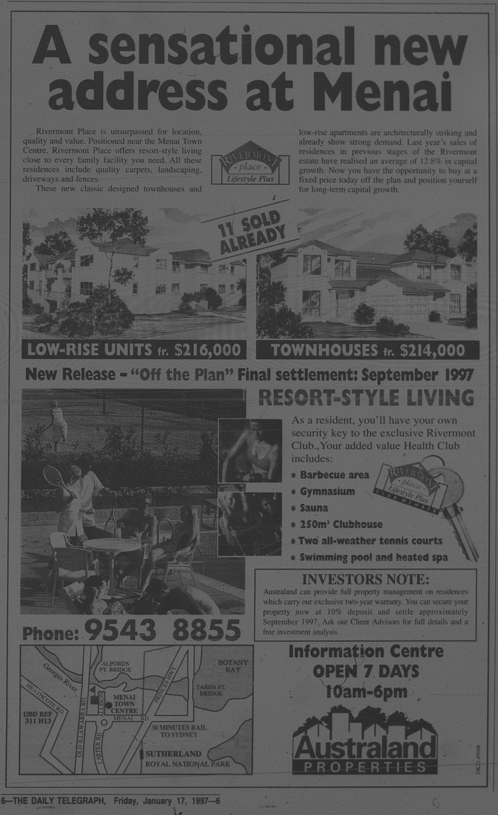
Rivermount Menai January 17 1997 daily telegraph 6

Source: Australand Properties. 1997. "A sensational new address at Menai" (Advertisement). The Daily Telegraph, January 11: 4. 

Saturday, 19 November 2022

Property Advert of the Week: Kirrawee Land Release (1962)

Below is a 1962 newspaper advertisement promoting a land release at Kirrawee in the vicinity of Duneba Avenue. Blocks were available from £995 ($1990) to £1795 ($3590). Adjusted for inflation (RBA Inflation Calculator) this would equate to between $30 500 and $55 000.

Kirrawee April 14 1962 daily telegraph 49

Source: Parkes Developments Pty. Ltd. 1962. "Fantastic Engineered Project at Kirrawee" (Advertisement). The Daily Telegraph, April 14: 49.

Monday, 10 October 2022

1985: Old Como Bridge becomes a footbridge and cycleway

The Old Como Bridge spanned the Georges River between Oatley and Como. It was a single track railway bridge that served the Illawarra and South Coast Railway Lines from 1885 until 1972, when a modern two track bridge was completed next to the original bridge. In 1985, the old bridge was reborn as a footbridge and a cycleway. It was offically opened on 16 December 1985 by Federal MP's Gary Punch (ALP, Barton) and Robert Tickner (ALP, Hughes).

  Como Bridge Walkway December 16 1985 daily telegraph 7

Source. Anon. 1985. "Spokes men bridge river gap". The Daily Telegraph, December 16: 7. 

Monday, 13 June 2022

NEVER BUILT SYDNEY: Cronulla Leagues Club & Endeavour Field Development (1968)

Cronulla Leagues Club proposal July 2 1968 daily mirror 59

Source: Anon. 1968. "$3m sports centre soon". The Daily Mirror, July 2: 59. 

When Cronulla entered the NSW Rugby League Competition in 1967, they played the first one and a half seasons at Sutherland Oval, Sutherland before relocating to Endeavour Field, Woolooware in mid 1968 (Currently known as PointsBet Stadium).

In 1968, plans were unveiled for a $3 million development of the site which promised:

  • A Football Stadium seating 25 000 people.
  • "Ultra Modern" Leagues Club
The leagues club was to be built to the west, where the Woolooware Bay Development stands today. 

The current leagues club commenced construction in 1973 and Stage One was opened in 1977. It's construction coincided with the club falling into financial difficulties. The Leagues club is currently being redeveloped at a cost of $20 million as part of the broader redevelopment of its land including apartment towers and a retail complex.

As for Endeavour field itself, the capacity eventuated at around 20 000, but compared with other football grounds, the model appears to show the ground to be ahead of the times with tiered seating around the stadium. Consider this against what fans at Kogarah Oval, Cumberland Oval (Parramatta) or the Sydney Sports Ground had to contend with at the time.

It was such an ambitious plan that didn't get to see the light of day. If it had gone ahead, Cronulla Leagues Club could have likely become the "Taj Mahal" of Sydney Clubs, dethroning its neighbours at St George Leagues (In its glory days) and even with redevelopments etc, being a leading club in Sydney today.

I think too, the redevelopment of the land in more recent times, would have had a different outcome, with a likely hotel development also included. The hotel itself may have even included in a future expansion in the 1980's or 1990's for instance. As for a retail complex on its land, still possible at its eastern end. 

Saturday, 14 August 2021

Property Advert of the Week: Stocks & Holdings Projects Home Sale (1973)

Below is a newspaper advertisement by Stocks & Holdings Projects that was published in The Daily Telegraph on April 7, 1973 (Page 41). Homes ready for immediate occupation were on offer at Jamisontown (Jamison Park Estate), Liverpool/Casula (Liverpool Links Estate) and Kareela. 

  Stocks and Holdings Advertisement April 7 1973 SM 41

In September 2020, I posted a newspaper advertisement from 1971 promoting the launch of the Liverpool Links estate. The 1971 advertisement did not list prices. 

Monday, 8 February 2021

MILESTONE: Opening of the Woronora Bridge (2001) - Part 2

This week is my second and concluding entry on the opening of the Woronora Bridge in 2001. Thursday (February 11), will mark twenty years since the bridge opened to the public.

Last week's entry focused on planning and construction of the bridge. As promised, this entry will focus on opening day.

The St George and Sutherland Shire Leader reported on February 6, 2001 that the Roads and Traffic Authority (RTA) had yet to announce who would officially open the bridge.  


The bridge was officially opened by NSW Premier Bob Carr. Before the road was opened to traffic, the public were invited to walk across the bridge for the cost of a gold coin donation. Activities and entertainment were provided on both sides of the bridge at Akuna Oval, Bangor and Sutherland Oval. 

Motorists were allowed to access the bridge the following day (February 12, 2001).

Below are newspaper reports associated with the opening.

The St George and Sutherland Shire Leader

February 13 2001


This article (below) was published on Page 2. 


The Daily Telegraph
February 12, 2001, Page 9


The Sydney Morning Herald
February 12, 2001, Page 3. 


Below are assorted news clippings relating to the opening uploaded to Youtube by "TheTVGuru3". 


Finally, while the bridge provided improved road connections to Menai, Menai Road continued to remain congested. This led to the construction of the Bangor Bypass from the bridge to Old Illawarra Road in 2005. The North-South section connecting the bypass Old Illawarra Road Menai to Alfords Point Road was completed in 2011. 


Monday, 1 February 2021

MILESTONE: Opening of the Woronora Bridge (2001) - Part 1

On February 11, it will be twenty years since the Woronora Bridge at Woronora was opened to motorists. the bridge linking Sutherland with Menai. replaced a two lane, low level bridge

In the first of this two part series, this entry will focus on the conception of the design and newspaper clippings relating to its planning and construction. Next week, news clippings will be posted.

Why a new bridge?

In 1981, a two lane bridge was completed across the Woronora River to replace a bridge that had been built in 1912. This bridge is still used today to carry local traffic in the suburb. 

However, Menai (and surrounding suburbs) was opened up to urban development. It had begun in the 1980's and therefore road links to and from Menai had to be provided.

The Alfords Point Bridge provided a major road link from Menai to Bankstown, but at that time was only three lanes.

Menai and River Roads which linked Menai with Sutherland provided challenging conditions for drivers in the Woronora Valley with its "S" Bends. This can still be experienced when you take the turnoffs for Woronora in any direction.

Above: This article from The Sydney Morning Herald in 1992 highlighted the difficulties of navigating through the Woronora Valley.

Source: Simpson, L. 1992. "The Coward of Granny's Elbow may be too slick". The Sydney Morning Herald, April 11:3. 

The Greiner Government when elected in 1988 promised to fund roadworks in the "Menai Area".

Planning and Construction

In 1990, plans were released. The design inspired by the curved Roseville Bridge called for a two decked bridges, each with two lanes. The first deck would be completed by 1994, while the second deck would not be needed until around "2000". 

The St George and Sutherland Shire Leader (November 20, 1990) reported that the Environmental Impact Statement (EIS) identified two concerns - Visual Impacts and Increased noise. The bridge was 32 metres high at its lowest point and construction was projected to cost $46 million. 


Construction commenced in 1994 with the State Government providing $6 million towards the construction of pylons.

When the Labor party formed Government in NSW in 1995, Premier Bob Carr provided no further funding citing environmental concerns, siding with Sutherland Council. Construction was stopped. 


Source: Morris, L. 1995. "Clash over $1bn 'shelved' roads". The Sydney Morning Herald, November 1:5.  

Bushfires at Menai in 1997 along with traffic studies highlighted the need for a new bridge and it led to the State Government to provide funding to complete the bridge. $47 million was allocated in mid 1998 to complete the bridge but with four lanes. 


Source: Bernoth, A. 1998. "Planned Woronora bridge gains two more lanes". The Sydney Morning Herald, July 24:4.

Finally, NSW Roads (successor of the Roads and Traffic Authority) uploaded a short film to Youtube documenting construction.


Part II next week. 

Monday, 22 June 2020

1992: Boat Harbour is handed to the public

Thomas Holt purchased the land that encompasses Boat Harbour at Kurnell in 1861. Holt was a major landholder in the Sutherland Shire and owned the entire Kurnell Peninsula.

It meant that the beach at Boat Harbour was also privately owned, unlike other Sydney beaches. Access was only via 4WD.

In 1992, his descendants (still under the Holt family name) handed Boat Harbour to the public.

Below is an article from September 1992 announcing the news.


Source: Cramsie, D. 1992. "Beach free for all". The Daily Telegraph Mirror, September 7:4. 

There was mention of a proposed resort (never proceeded). This will be subject to a separate entry in the future.

Boat Harbour is now an Aquatic Reserve and remains pristine. Currently the reserve is managed by the NSW Department of Primary Industries. 4WD's can access the park but are banned from driving on the dunes at a cost of $30 per vehicle.