Showing posts with label highways. Show all posts

Monday, 30 November 2020

MILESTONE: ANZAC Bridge turns 25 (1995-2020)

It's Sydney's No. 2 Bridge - ANZAC Bridge. On Saturday, the bridge will celebrate 25 years of service to Sydney.

The ANZAC Bridge replaced the swing bridge that was opened in 1903. The swing bridge has been retained for heritage purposes. The bridge also improved road travel for commuters travelling along the Victoria Road corridor, eliminating the delays associated with the previous bridge and doubling road capacity (from two to four lanes each way).

For boaties, the new bridge was taller and boats could easily navigate in and out of Blackwattle Bay.

The bridge was formally named ANZAC Bridge on November 11 1998.

Below is media coverage from The Daily Telegraph Mirror.

On December 4, 1995, The Daily Telegraph Mirror published a special four page liftout focusing on the official opening ceremony. On the previous day around 65 000 Sydneysiders walked across the bridge before being opened to traffic that evening.


The same edition (PM edition) also carried a page one report on the first peak hour run for the bridge. For the first weeks of operation, only two lanes were open each way. Congestion on the western approaches was heavier than normal.


The Daily Telegraph Mirror attempted to identify the causes of the congestion the following day (December 5).

Monday, 23 November 2020

MILESTONE: ANZAC Bridge turns 25 (1995-2010) - Poster from "The Daily Telegraph Mirror"

This entry is a teaser for next weeks entry. At the end of next week (December 4) the ANZAC Bridge will celebrate 25 years of service to the people of Sydney.

Below is a A2 sized poster that was published in The Daily Telegraph Mirror on November 30 1995.


Monday, 17 February 2020

2001: Sydney's Motorway Revolution

A map of freeway projects (approved, under construction or proposed) in Sydney in 2001. Full citation below.

In early 2001, Federal Transport Minister (and Deputy Prime Minister) John Anderson announced that the Federal Government would provide $350 million to cover the $1.25 billion cost of the construction of the Western Sydney Orbital.

Across Sydney, it was estimated that over six years (2001-2007) $3 billion would be spent on the construction of new freeways which promised travel savings, increased productivity, lower running costs for trucks and jobs.


Source: Wainwright, R. 2001. "Sydney's motorway revolution". The Sydney Morning Herald, January 5:1. 

The Western Sydney Orbital (Westlink M7) was completed in 2005 ahead of schedule, however the Lane Cove Tunnel was opened in 2007 and the Cross City Tunnel in 2005. The M5 East was opened in December 2001.

In 2013, plans were unveiled for the  F3 extension to the M2 Motorway (NorthConnex). Approval was given in 2015 by the NSW Government. Opening is slated for mid year.

While NorthConnex will run under Pennant Hills Road, a proposed route in 2001 saw the road running from Macquarie Park to Wahroonga.


Source: Wainwright, R. 2001. "Pressure on to complete the city's traffic puzzle". The Sydney Morning Herald, January 5:4. 

Below is additional coverage from the January 5, 2001 edition of The Sydney Morning Herald. 


Monday, 17 September 2018

MILESTONE: Warringah Expressway turns 50


Source: Anon. 1968. "The Super Road That Opens Today". The Daily Telegraph, June 18: 3.

In June, the Warringah Expressway turned fifty without any fanfare. But there was some fanfare when it opened on June 18, 1968, by NSW Governor Sir Roden Cutler.

The first stage was from the Bradfield Highway at North Sydney through to Miller Street, Cammeray. It was extended to Willoughby Road in 1978.

It was envisioned that the Warringah Expressway would be extended through to Balgowlah and Frenchs Forest. However, the NSW Government is determined that this will be fulfilled through the proposed tunnel under Middle Harbour to the Burnt Bridge Creek Deviation at Balgowlah.

Younger people are used to a major road opening early on a Monday morning. How about a new road opening during the day on a Tuesday? Sydneysiders were able to drive home on the new road.


Source: Anon. 1968. "New Expressway Speeds City Traffic". The Daily Telegraph, June 19: 3.

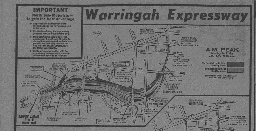
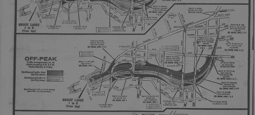
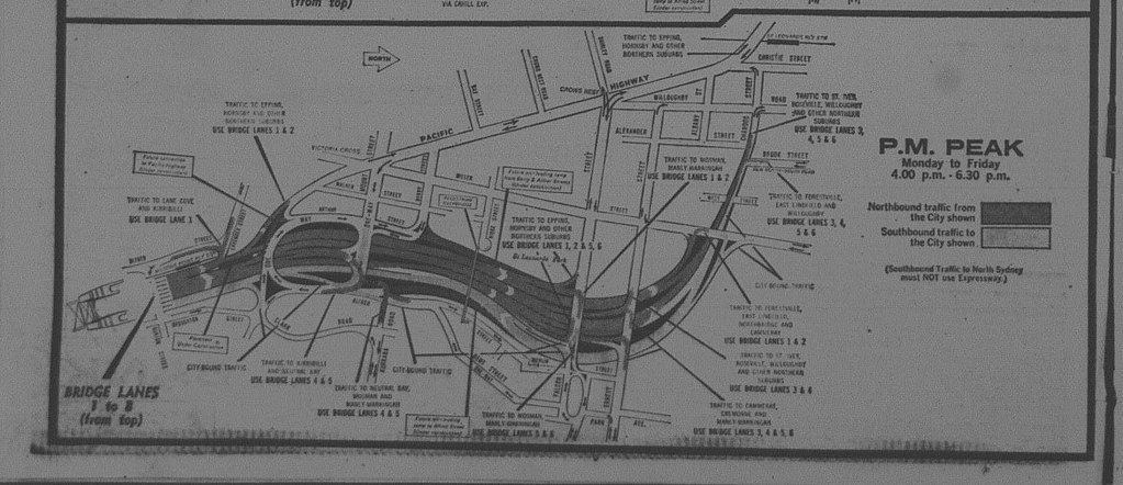
For the opening brochures explaining the traffic flow arrangements were provided to motorists, along with newspaper advertisements (see below)


Source: Anon. 1968. "Warringah Expressway". The Daily Telegraph, June 18: 10.

I have included enlargements of the arrangements below:


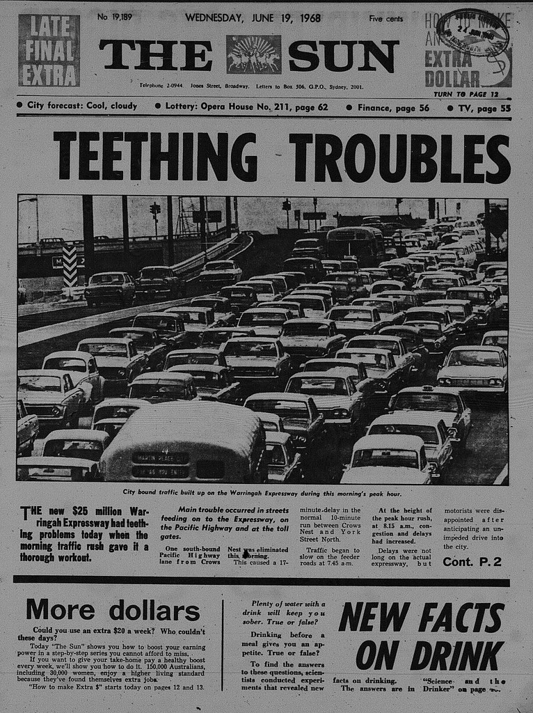
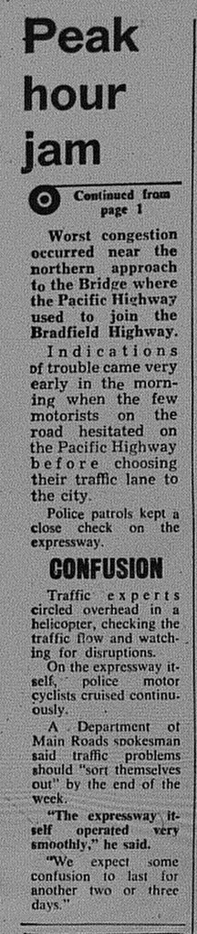
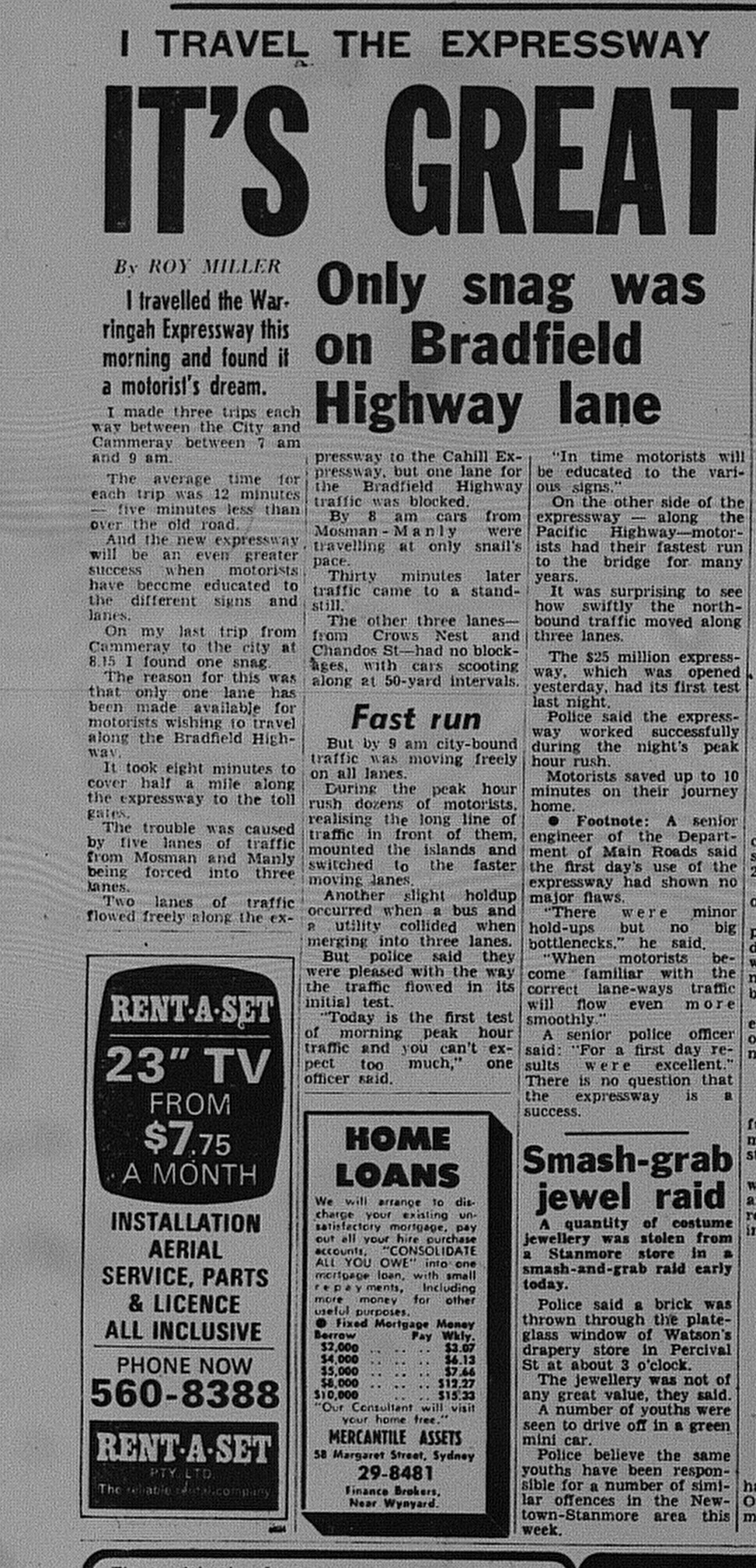
There were some teething problems associated with traffic approaching the freeway as The Sun reported on June 19, 1968.


But overall they seemed happy.


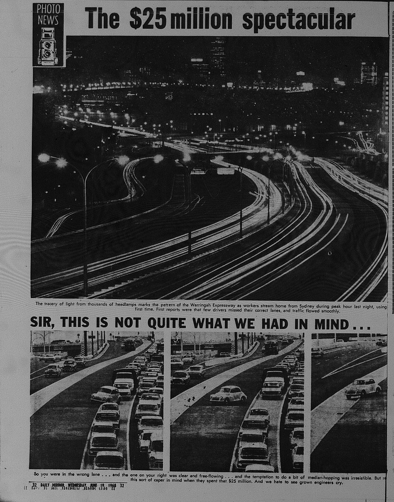
And a photo spread from the June 19, 1968 edition of The Daily Mirror. 


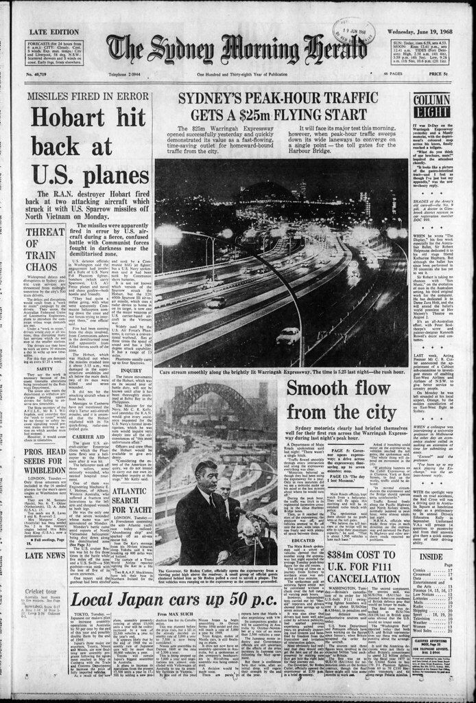
Page One of The Sydney Morning Herald on June 19, 1968had another good photo taken during the evening peak from opening night.


Monday, 14 August 2017

MILESTONE: The M5 Motorway turns 25 (1992)

Today (August 14) is the 25th Birthday of the M5 Motorway. I have obtained material from the time of opening in 1992.


Source: Interlink Roads Pty Ltd. 1992. "M5" (Advertisement). The Sunday Telegraph, August 9: 48. 

When opened in August 1992, Stage 1 ran from Fairford Road, Padstow to the Hume Highway at Casula. Drivers were charged $1.50. When extended to King Georges Road, Beverly Hills several months later, the toll rose to $2. In today's money, that would be equivalent to $3.64. Excluding GST, motorists pay $4.04 to use the same road at present ($4.60 with GST).

The opening of the M5 was marred by protests. Premier John Fahey left it to his deputy and roads minister Wal Murray to open the road. Driving legend Peter Brock was the first driver on the new motorway. He was the marketing ambassador for its owner Interlink Roads.


Source: Skelsey, M. 1992. "M5 drama as 300 heckle Murray". The Daily Telegraph Mirror, August 15: 7. 

One challenge with new toll roads in Sydney has been the ability to attract traffic upon opening. The M5 was no stranger. Opening Day had virtually no traffic.

Even a year later, it was being criticized for the fact it took people "nowhere"


Source: Allan, C (Editor). 1993. "Making M5 a road to somewhere" (Editorial). The Daily Telegraph Mirror, November 1: 10. 

Not even promoting the motorway as the only way into Sydney worked.


Source: Stapleton, J. 1992. "This way to the M5 but where's the free way?". The Sydney Morning Herald, August 25: 4. 

Fast forward a quarter of a century later and the M5 is one of Sydney's most congested roads. Not even adding second and third lanes (1999 & 2011) in each direction would relieve congestion. The M5 East (2001) connected the motorway to the Orbital network, allowing motorists direct access into central Sydney, Sydney Airport and Port Botany.

Monday, 7 August 2017

1962: Tom Ugly's Bridge as a double deck bridge?

In 1962, there was only one crossing over Georges River to link the Sutherland Shire with the rest of Sydney - Tom Ugly's Bridge. The bridge could only carry three lanes of traffic. The postwar years saw a boom in the population and congestion on the bridge approaches was becoming an ever increasing problem.


Source: Anon. 1962. "Engineer proposes an answer to the chaos". The St George and Sutherland Shire Leader, February 8: 1. 

One engineer - James Stewart had a plan that would allow for an additional three lanes built atop the existing lanes of the bridge. It was an efficient proposal, but the challenge would have been with the approaches to the bridge. This may have had implications on both sides of the bridge as we see it today. 


Source: Anon. 1962. "Cars could drive over the top of Tom Ugly's". The St George and Sutherland Shire Leader, February 8: 3. 

It was not until 1987, that a second bridge was built roughly parallel to the existing bridge - Georges River Bridge which would carry southbound traffic on the Princes Highway, allowing tom Ugly's Bridge to carry northbound traffic only. 

Also, he suggested a rail line traveling from Caringbah to Rockdale to relieve congestion on the single deck Como Bridge with the tracks incorporated into the soon to be built Captain Cook Bridge. He felt that while tenders had closed, the design could be modified. The line would have followed the corridor for the F6 (Southern) Freeway and rejoined the main Illawarra line at Rockdale. This would have led to significant reductions in commute times on the Cronulla branch line and provided South Coast services a second route through Southern Sydney.


Monday, 15 May 2017

1997: M2 Motorway opens to the Public

In 1997, those in the booming North West suburbs now had a motorway that would make travel much easier, but yet they were reluctant to use it despite the reductions in travel time that it promised.


Source: Hilferty, T & Walsh, P. 1997. "M2 Chaos: Traffic anger as tollway opens". The Daily Telegraph, May 26: 1 & 2. 

 And then there were those who opposed it because it involved the loss of trees and vegetation. They were vocal from the planning stages and even on opening day wanted to spoil the celebrations. While for others, it was the fact one had to pay for the toll ($2.50).

Three months later, people still stayed away.

  
Source: Gibson, B. 1997. "Going nowhere fast". The Daily Telegraph, August 9: 15. 

Eventually, the motorway did fill up with traffic and would form a piece of the Sydney Orbital network. Early in 2006, the M7 allowed drivers on the M2 a direct link through western Sydney down to the M5 Motorway and Hume Highway. In 2007, the Lane Cove Tunnel connected the M2 to the Gore Hill and Warringah Freeways.

During 2011 and 2013, an additional lane was added in each direction with improvements to on and off ramps.

Currently, the NorthConnex Project will connect the M2 Motorway to the M1 Motorway. This will be completed in 2019. Drivers will no longer need to use Pennant Hills Road or the Pacific Highway if driving in or out of Sydney.

Monday, 17 April 2017

1997: Plans for the Eastern Distributor are unveiled


Source: Bissett, K. 1997. "Motorway sinks but toll will rise". The Daily Telegraph, April 10: 8

Did you know that it is 20 years ago this month that plans for the Eastern Distributor that we see today were unveiled?

While there had been calls for the entire road to be placed underground, attempts were made to make it appear more environmentally sensitive. This included sinking sections of the motorway under South Dowling Street and the landbridge connecting The Domain with the Royal Botanical Gardens

The opening was slated for 2000 (The Daily Telegraph) but was opened ahead of schedule in December 1999, sticking to the promised $3 toll.


Source: Morris, L. 1997. "New $1bn plan for eastern M-way". The Sydney Morning Herald, April 15: 4. 

Monday, 26 October 2015

1991: The Harbour Bridge Toll spike

I'm posting this out more for interest's sake this week, because when I came across it, it just took me with a lot of interest, given the debate about tolls in Sydney to access roads.

I recall as a kid during the 1990s that it cost about $2 to cross the Sydney Harbour Bridge (or tunnel) which to many seemed like a small fortune.

That is pretty good compared to three dollars that the Greiner Government was proposing as a way of reducing air pollution in Sydney which was still causing headaches to all.

It was not until 2002 that the toll was increased to $3. There was an increase from $2 to $2.20 in 2000 due to the introduction of the Goods and Services Tax.

The toll is still $3 if you travel between 9:30am and 4pm on weekdays, and rises to $4 during peak periods (as a means of trying to reduce traffic flow). However, travel late at night or on weekends and you now pay a nice $2.50.


Source: Worthington, J. 1991. "Harbor Bridge $3 Toll Tipped".  The Daily Telegraph, November 12: 7.

Monday, 14 September 2015

SYDNEY TRANSPORT VISION: Southern Sydney Road & Rail Transport Vision (1962)


Source: Anonymous. 1962. "Engineer proposes solution to the chaos". The St George and Sutherland Shire Leader, February 8: 1. 

In 1962,  engineer James Stewart in the Sutherland Shire drew up a vision to improve transport across the city's southern suburbs. His idea was straightforward

*Build a second road deck over the existing Tom Uglys Bridge. He claimed it could be done in 20 days with six men.
*Use the F6 Corridor to build a new heavy rail line linking Rockdale with Caringbah and be incorporated into the new Taren Point Bridge. For Cronulla rail commuters, this would lead to a big reduction in travel times to and from the city.

The new rail link would have also eliminated the need to build what is now the current rail bridge at Como, but I think this was inevitable in terms of providing a smooth service between the South Coast and Sydney.

Monday, 29 September 2014

SYDNEY TRANSPORT: Opening of the Gladesville Bridge (1964)

Photo was taken by the Author.

This year the Gladesville Bridge turns 50, and at this stage looks like it will be celebrated with little fanfare. Those who drive over it know little about its engineering feats at the time which makes it a special bridge. Did you know that at the time of completion, it was the longest concrete arched bridge in the world? The longest span is 305 metres while the length of the bridge itself is 579 metres.

But why was the bridge built? It was built to replace a bridge just 300 metres to the west, which would link what is currently Huntleys Point Road at Huntleys Point with Victoria Place at Drummoyne. The bridge itself opened in 1881.


Source: Star Photo Co., Company. Year Unknown.


It could only carry one lane of traffic in each direction plus a tramway. It had a section that could be swung open to enable taller ships to sail through. By the 1950s there were mechanical problems which would stop the bridge from closing. Add in urban growth and increasing use of the car by the growing populace and there was a problem.

The original Gladesville Bridge struggled to cope with increased traffic movements as this image from 1962 shows.
Source: Department of Main Roads. 1962. Accessed August 19 2014, http://www.ozroads.com.au/NSW/Freeways/GladesvilleBr/16.JPG.

Meanwhile, there were plans to build a freeway running west from the Sydney CBD through Gladesville and the North Shore to link what is now the Pacific Motorway (M1) and north-west Sydney (The Castlereagh Freeway which evolved into the current M2 motorway). The bridge itself would form a section of the future freeway like the nearby Tarban Creek bridge which was completed the following year (1965).

Here is how the press covered it all the way back on October 2, 1964, when it was officially opened by Princess Marina. Despite the engineering achievements, it had to compete for attention amongst other news stories at the time. It was reported that 6000 attended the opening before being opened to traffic for peak hour. The Daily Telegraph reported congestion on the bridge and approaches occurring that evening in its paper the following day (October 3).


Source: Anonymous, 1964. "6000 see bridge opened: Ceremony by Marina", The Daily Mirror, October 2: 3. 

The Sydney Morning Herald was the only paper that provided special coverage of the opening. It produced a special supplement focusing on road projects in NSW and focused on the bridge itself. I have decided to share an illustration that they produced of its construction.


Source: Anonymous. 1964. "Much Work On Design." The Sydney Morning Herald, October 2: 14. 

The original Gladesville Bridge no longer remains but two of the spans remain; one each on each side of the Parramatta River.

The span itself
Photo was taken by the Author.