Showing posts with label freeways. Show all posts

Monday, 26 August 2019

MILESTONE: Opening of Syd Enfield Drive (1979)

This year is forty years since Syd Enfield Drive was completed. Originally the road was known as the Bondi Junction Bypass. The section of road was part of a vision to form the (never built) Eastern Suburbs freeway that would connect Bondi Junction to the city.

It would also form part of the commercial redevelopment of the suburb along with the construction of the Eastern Suburbs railway line, and would eliminate through traffic through the centre of Bondi Junction.

Construction took less than two years before being opened to traffic on 9 January, 1979. The road was opened by local State MP and Minister for Consumer Affairs - Syd Enfield.

In 1988, the bypass was named Syd Enfield Drive in honour of the former MP.

With traffic now bypassing the commercial heart of Bondi Junction, it led to creation of the Oxford Street mall.


Source: Anon. 1979. "By-pass today, mall tomorrow". The Sydney Morning Herald, January 10:1. 

Monday, 27 November 2017

1970: The Origins of Shorelink

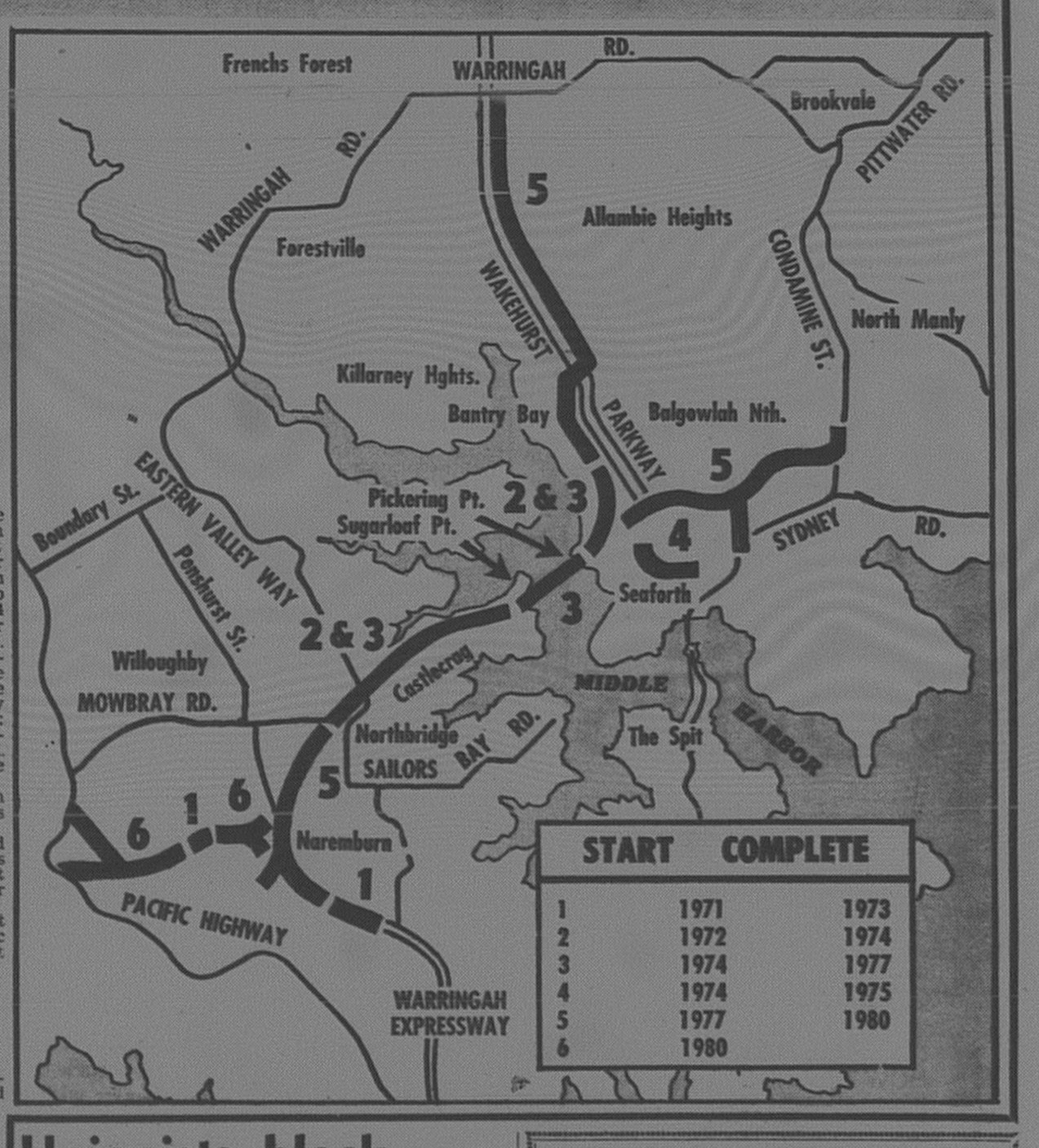
I was having a look at the proposed corridor for the proposed Shorelink tunnel and noticed that the route is virtually identical to that proposed by the NSW Government in 1970.

The only difference between the 1970 and 2017 is that the 1970 proposal was above ground whereas it will be tunneled under this plan.

1970

Middle Harbour Bridge April 3 1970 daily telegraph 3 closeup

Source: Anon. 1970. "Bridge for Middle Harbour". The Daily Telegraph, April 3: 3.

2017

Spit Bridge tunnel map

Source: NSW Government (2017). [image] Available at: http://www.abc.net.au/news/2017-07-18/spit-bridge-tunnel-map/8718496 [Accessed 20 Nov. 2017].

Below is the full article on the 1970 scheme as covered by The Daily Telegraph. This included a proposal for a double-decker bridge over Middle Harbour. The estimated cost was $70 million ($781 million in today's money). Compare it with the estimated $3 billion to be spent with the 2017 scheme which is tunneled. Estimated completion - 1980.


Source: Anon. 1970. "Bridge for Middle Harbour". The Daily Telegraph, April 3: 3.

Monday, 28 August 2017

MILESTONE: Sydney Harbour Tunnel turns 25 (1992)

Another milestone to celebrate this week. This week we celebrate 25 years of service of the Sydney Harbour Tunnel to the citizens of Sydney.

With congestion increasing on the Sydney Harbour Bridge in the 1980s, the need for a second harbour crossing was pushed further.

Plans for a harbour tunnel evolved throughout the 1980s, but it was not until 1986 where concrete plans were proposed. Initially, the tunnel was to run from Hickson Road, Millers Point and run west of the Harbour Bridge. Like the final plans, it would meet the Warringah Freeway at Mount Street, North Sydney.


Source: Coultan, M. 1986. "Tunnel: how pipedream will become pipeline". The Sydney Morning Herald, March 14: 1. 

Several months later, the proposal we see today was conceived in an attempt to reduce construction costs. While the motives might not be just, the decision had a long run outcome - The Harbour Tunnel would form a piece in what has evolved into Sydney's orbital network of freeways. Under the Hickson Road plan, this would not be possible.


Source: Coultan, M. 1986. "Slimmer Harbour tunnel to save $35 million. The Sydney Morning Herald, December 17: 1 & 2. 

There was one proposal that was tendered by a firm that for around $100 million, four lanes could be constructed above the existing road deck to increase road capacity. This was published in The Daily Telegraph Mirror on August 27, 1992, in a special supplement to mark the opening of the tunnel.


Plans to proceed with construction were announced by the NSW State Government on April 27, 1987. This included increasing the Harbour Bridge toll from 20 cents to $1 to fund its construction. It rose to $2 by 1992.

Kirribilli residents objected to the tunnel, particularly as the air ventilation stack would be located at Bradfield Park. Today, anyone using the park would be unaware of its presence, landscaped into the terrain.

Transfield and Kumagai Gumi were awarded the contract to construct the tunnel. Construction largely took place off-site with tunnel sections built at Port Kembla, before being towed into Sydney where they were sunk into place at the bottom of Sydney Harbour. Official work commenced in 1988.

On August 29, 1992, NSW Premier John Fahey officially opened the tunnel. The opening was marred by protestors that wanted to disrupt the event. The following day, the public was invited to walk through the tunnel. The walk acted as a fundraiser for charity.


Source: Wilkins, M. 1992. "Light at the end of the tunnel...Greenies 'crash' the party". The Sunday Telegraph, August 30: 4.  

The tunnel was opened to traffic at 3am on August 31, 1992. It survived its first peak hour test without glitches.


Source: de Vine, B & Toy, N. 1992. "It's Perfect: Tunnel opens with dream run". The Daily Telegraph Mirror, August 31: 1 & 2. 

Like any expansion to a road, a new road will only take the pressure off an existing road for a short period of time before traffic levels return to previous levels. It's not uncommon for traffic on the Warringah Freeway to be banked "past the channel nine tower" at Willoughby in morning peak hour irrespective of whether you are bridge-bound or tunnel bound. Add the congestion once you cross the bridge, and trek down the Eastern Distributor towards Sydney Airport. An estimated 200 000 cars crossed the Sydney Harbour Bridge daily at the time of opening in 1992. Today, it is estimated to be around 165 000 cars that cross the bridge. When combined with RMS data of approximately 90 000 cars that access the Harbour Tunnel, 245 000 cars cross the harbour each day. 

Statistics of Interest:

  • Construction costs amounted to $560 million.
  • Estimated savings in travel time - 10 minutes.
  • 4500 workers involved in construction along with 300 contractors.

The Daily Telegraph Mirror to mark the opening provided its readers with a special poster outlining construction. 


Monday, 15 May 2017

1997: M2 Motorway opens to the Public

In 1997, those in the booming North West suburbs now had a motorway that would make travel much easier, but yet they were reluctant to use it despite the reductions in travel time that it promised.


Source: Hilferty, T & Walsh, P. 1997. "M2 Chaos: Traffic anger as tollway opens". The Daily Telegraph, May 26: 1 & 2. 

 And then there were those who opposed it because it involved the loss of trees and vegetation. They were vocal from the planning stages and even on opening day wanted to spoil the celebrations. While for others, it was the fact one had to pay for the toll ($2.50).

Three months later, people still stayed away.

  
Source: Gibson, B. 1997. "Going nowhere fast". The Daily Telegraph, August 9: 15. 

Eventually, the motorway did fill up with traffic and would form a piece of the Sydney Orbital network. Early in 2006, the M7 allowed drivers on the M2 a direct link through western Sydney down to the M5 Motorway and Hume Highway. In 2007, the Lane Cove Tunnel connected the M2 to the Gore Hill and Warringah Freeways.

During 2011 and 2013, an additional lane was added in each direction with improvements to on and off ramps.

Currently, the NorthConnex Project will connect the M2 Motorway to the M1 Motorway. This will be completed in 2019. Drivers will no longer need to use Pennant Hills Road or the Pacific Highway if driving in or out of Sydney.

Monday, 7 November 2016

1975: F6 Southern Tollway opens

NSW Premier Tom Lewis cuts the ribbon to open the Southern Tollway on July 24, 1975.

Source: Anonymous. 1975. "Lewis Opens Super Road". The Illawarra Mercury, July 25, 3. 

I am currently on a teaching appointment to a school in the Illawarra region and I am dependent on the F6 Southern Freeway (Renamed Princes Motorway) to get me there in just one hour.

I am one of thousands of commuters that are dependent on the freeway to get us from Sydney to Wollongong or vice versa each day, whether it is for work, education (University of Wollongong), to visit family or escape Sydney to visit the Illawarra or South Coast. It acts as a lifeline between the two cities. 

In past years, a trip by car to Wollongong entailed one to navigate the old Princes Highway and then snake their way down Bulli Pass to get into Wollongong. It was not a safe trip either.

Planning for the freeway did begin in the 1930s but World War II halted planning. This was revisited in the 1950s with the vision to build a freeway from Sydney through to Wollongong. A corridor was designated from Waterfall to St Peters and remains untouched, though a number of parks run into the corridor like Scarborough Park at Kogarah. The only section built was Captain Cook Bridge at Taren Point which opened in 1965. Meanwhile, a freeway corridor was reserved in Wollongong, which incorporated Mt Ousley Road which had been built in World War II to improve transport movements from Sydney to the Illawarra.


Source: Anon. 1970. "Toll Road Job to Start Soon". The St George and Sutherland Shire Leader, June 10: 11.

The corridor from Waterfall to Bulli Tops was gazetted in 1952. Approval to construct a km tollway was given in 1970. Construction commenced in June 1970. After delays in construction (original completion was late 1974), the $18 million tollroad was officially opened to traffic on July 24 1975 by NSW Premier Tom Lewis. The premier hailed it as a "masterpiece of design and workmanship". Motorists were charged a toll of 40 cents to drive between Waterfall and Bulli Tops. With a speed limit of 110km/h, a person can cover the entire 22 kilometre freeway in just 12 minutes.


Source: Anon. 1975. "Cars Queue to Try Tollway: Premier Opens Super Shortcut". The Illawarra Mercury, July 25: 3. 


With the route prone to fog, electronic signage was provided to alert drivers to changes in road conditions including variable speed limits. This is shown in the WIN News Illawarra archives which was shown in 2015 to mark its 40th anniversary.


Source: Win News Illawarra. (2015)."Construction of the F6 Freeway. [Online Video]. 21 July 2015. Available from: https://www.youtube.com/watch?v=riqehUWuHdQ. [Accessed: 3 November 2016].

 Tolls were abolished in 1995 to encourage heavy vehicles to use the freeway instead of the Princes Highway which "had a poor accident record", and reduce business costs. 


Source: de Vine, B. 1995. "State Government abolishes F6 charge". The Daily Telegraph Mirror, May 17:5.


Source: Zeller, F. 1995. "F6 a free way ...but Knight shies from M4, M5 pledge". The Daily Telegraph Mirror, July 1: 9. 

In 2000, an interchange was opened at Helensburgh to improve access to the suburb along with Stanwell Park.

As for linking the (now) Princes Motorway into Sydney's network of motorways, the planning continues more than six decades later. The NSW Government has now referred to the southern freeway as "SouthConnex" and is planned to be a priority once the NorthConnex and West Connex projects are completed. Below is a recent report from Seven News relating to the F6 Motorway.


Monday, 15 December 2014

1995: Sydney's Olympic Road (M4 East)

With the WestConnex now planning to snake its way under Sydney, lets look at one dead scheme that was proposed for the inner west from 1995 as a solution to the traffic gridlock on Parramatta Road.

However it was not going to be a motorway and the road would run above ground through a section of Concord and Five Dock before connecting with the City West Link at Wattle Street, Haberfield. A wise idea to not proceed with it because I think it wouldn't have had any major impact on traffic on Parramatta Road. The bottlenecks would have shifted east along the road into Haberfield and Ashfield. This appears that controlling traffic there would be so challenging as you'd not just manage traffic coming out of the new road but also the City-West Link, Parramatta Road and Frederick Street, Ashfield.


Two alternative routes were considered. One would have included a tunnel under Parramatta Road like the WestConnex Motorway but would have required closure of parts of Parramatta Road or the construction of a viaduct along Parramatta Road.

Source: Larkin, J. 1995. "RTA in push for Olympic road link," The Sunday Telegraph, August 20: 5.

Monday, 9 June 2014

1987: Freeway free-for-all

To coincide with the opening of the Georges River Bridge (southbound bridge for the Princes Highway at Tom Uglys Point) in October 1987, The Daily Telegraph ran a special photo spread showing the construction of freeways across the city including the Western Distributor, Southern Cross Drive and the F3 (Sydney-Newcastle Freeway). The road building at the time was deemed by journalists to be the most "ambitious" in years.


Source: Reid, C. 1987. "Freeway free-for-all," The Daily Telegraph, October 13: 26-27.