Showing posts with label Visions of Sydney (Series). Show all posts

Monday, 22 June 2026

VISIONS OF SYDNEY: Football's Field of Dreams at E S Marks Athletics Field (2006)

This is the last entry in our current Visions of Sydney Series. With the 2026 FIFA World Cup currently being held in Canada, Mexico, and the United States, I recently came across a 2006 article from The Daily Telegraph. At the time, the Football Federation of Australia (FFA) proposed a centre of excellence for Australian Football to support the development of football sides such as the Socceroos, Matildas, and Olyroos.

The proposed site was E S Marks Field at Moore Park

It was a good proposal. It would have allowed other sports to continue using the facility, including Athletics and Rugby League, but it never got off the ground.

Australia is one of four nations in the 2026 World Cup that does not have a national base or centre of excellence. However, it has been reported in recent months that it is exploring the option to create such a centre at Sydney Olympic Park. 

Sydney to get a soccer field of dreams April 11 2006 Daily Telegraph 40-41

Source: Smithies, T. 2006. "Sydney to get a field of dreams". The Daily Telegraph, April 11; 40-41.

Next Week, Remember This? will return for its mid-year run.


Monday, 8 June 2026

VISIONS OF SYDNEY: Bondi of the future exhibition - revisited (1968)

Bondi of the Future Ad November 13 1968 Wentworth Courier 19 enlarged

Sourced from: Grace Bros Bondi Junction. 1968. "See Bondi of the future" (Advertisement). The Wentworth Courier, November 13: 19.

Back in 2014, I posted an entry which would appear under Never Built Sydney, focusing on a 1968 Exhibition at Grace Bros, Bondi Junction, involving University of New South Wales Architecture students displaying their visions for Bondi in the year 2000.

I have posted this entry under Visions of Sydney as it aligns with "never builts" or future visions for redevelopment of suburbs that never proceeded or were early or alternate schemes or in this instance, university students predicting how Bondi may look over thirty years into the future.

Below is a newspaper advertisement from Grace Bros showing one of the proposed schemes. It is the same featured from the article I posted back in 2014, but with Ben Buckler in the foreground. Its familiar midrise unit blocks would not have survived. It would have been completely rebuilt from scratch, incorporating a mixture of residential and tourist development. Having a hotel located there would have utilised not just the views of the beach, but also those of the ocean. If the idea had evolved into a real proposal and then been built, it would likely have been amongst Sydney's most famous hotels, simply for its headland location.

Bondi of the Future Ad November 13 1968 Wentworth Courier 19

Source: Grace Bros Bondi Junction. 1968. "See Bondi of the future" (Advertisement). The Wentworth Courier, November 13: 19.

And there is one feature from The Wentworth Courier (20 November 1968) that either shows another scheme or could be part of the initial scheme. I think the featured model could be one of how Campbell Parade may have been envisioned as looking in the year 2000.If so, much taller, larger buildings were predicted line the strip than in 2000 and 2026, six decades later. 

Bondi of the Future November 20 1968 Wentworth Courier 4 enlarged Bondi of the Future November 20 1968 Wentworth Courier 4

Source. Anonymous. 1968. Untitled. The Wentworth Courier, November 20: 4. 

Related Entry

NEVER BUILT SYDNEY: Bondi of the Future Exhibition (1968)


Monday, 18 August 2025

VISIONS OF SYDNEY: Bondi Junction Piazza (2001)

bondi junction square September 4 2001 AFR page unknown enlargement
Full Citation Below

This is the last entry in our current series of Visions of Sydney. In 2001, Waverley Council had plans to build a Piazza in Bondi Junction to revitalise the Oxford Street mall. Retailers were struggling to attract customers into the mall following the opening of the undercover Bus/Rail Interchange, along with the redevelopment of Westfield Bondi Junction (completed 2004). 

Piazza-style malls were a trend at the time in Sydney, as reflected with The Forum at Leichhardt (1998) and Kogarah Town Square (2003). Apart from retail, the malls were surrounded by a residential population residing in apartment buildings (low to mid-rise). 

The piazza was to be centred on the site of Bronka Arcade and buildings adjacent to it. Low-rise apartment buildings would surround the Piazza along its western and eastern ends, while the podium of Eastgate Plaza would be moved forward into Spring Street to connect the complex with the piazza. This would have required the closure of Spring Street between Bronte Road and Newland Street.

  Bondi Junction Civic Square September 4 2001 AFR page unknown 
Source: Harley, R. 2001. "Council is thinking outside the square". The Australian Financial Review, September 4: page unknown. 

Monday, 11 August 2025

VISIONS OF SYDNEY: Otis Personal Rapid Transport System for Central Sydney (1974)

Did you know that in the 1970s, the Otis Elevator Company proposed a personal rapid transport system to transport people in central Sydney?

Below is a newspaper feature from The Sydney Morning Herald in 1974. 

Along the four-mile proposed route (Approximately 6.5 kilometres) from the Sydney Opera House to Central Station, vehicles seating up to 24 people would operate either at ground level or on elevated rails. This was seen as a solution to traffic congestion and air pollution in central Sydney. It was even suggested that it could be used to serve the Northern Beaches, which at the time (and still is) not served by heavy rail. 

Monorail proposal sydney January 30 1974 SMH 3

Source: Anon. 1974. "Air cushion travel proposed". The Sydney Morning Herald, January 30: 3. 

Monday, 4 August 2025

VISIONS OF SYDNEY: Circular Quay facelift (1972)

Over the years, there have been several visions to give Circular Quay a facelift, many of which have never become a reality, either in part or in whole.

Below is one vision from 1972 that was published in The Daily Telegraph. In summary, the vision was to:

  • Renovate the wharves with glazing (renovations did not occur until the 1990s, and Wharf 3 was rebuilt in the 1980s to accommodate the Freshwater Class ferries and their automated gangways.)
  • Covered walkway from the Sydney Opera House would be extended down to the Cahill Expressway.
  • A waterfront public square, tavern and restaurant along the waterfront at East Circular Quay.
  • New paving
  • Electric Train with open-air carriages (carnival style)
  • New lighting
Our Quay to the future December 13 1972 daily telegraph 28-29 
Source: Anon. 1972. "Our Quay to the future". The Daily Telegraph, December 13: 28. 

Monday, 28 July 2025

VISIONS OF SYDNEY: Sydney Light Rail Loop (1987)

Eastern Suburbs light rail link july 20 1987 daily telegraph 5
Source: Grimshaw, P. 1987. "Plan to put commuters on right track". The Daily Telegraph, July 20: 5. 

In 1987, an independent engineering team unveiled plans for a "Suburban Circle Line", a light rail loop that would have served the inner city, eastern suburbs and inner west. The argument was that the infrastructure was already there or followed former tram corridors e.g. middle of ANZAC Parade. It was claimed that 14% of the route would need to be built from scratch.

This would have encompassed two of the light rail routes that operate today - L1 line (Central Station - Dulwich Hill via Pyrmont and Lilyfield)  and L2 (From Central Station to Randwick),along with the line looping down to La Perouse using the former tram corridor along ANZAC Parade before turning towards Botany and would have included a stop at Sydney Airport. It would then head towards Dulwich Hill. 

It has to be asked - Is it still possible for this vision to become reality? Yes. The L1 and L2 routes already encompass a large share of the route. The former tram corridor along ANZAC Parade is still there - It can be reverted for Tram use. The La Perouse to Dulwich Hill component though isn't clearly shown in the map that featured in the newspaper clipping, though I think they would have considered using the Port Botany-Sydenham Freight Line as part of any route, however considering that the line is used for freight purposes may render that as unfeasible along with the final section from Marrickville to Dulwich Hill. 

Our readers or followers of public transport might have their own ideas or may know more. Feel free to leave a comment or two. 

Monday, 21 July 2025

VISIONS OF SYDNEY: Widening George Street Footpaths (1986)

George Street Pedestrianisation December 9 1986 Daily Telegraph 3

Source: Nicholson, L. & Mulligan, M. 1986. "City to open up for pedestrian network" (1986). The Daily Telegraph, December 9: 3.

Visions of Sydney is back for the next five weeks, as I explore some of the visions that never quite became a reality in Sydney, or were an early scheme or proposal for an eventual project or scheme. This focuses on transport and public spaces, as Never Built Sydney encompasses buildings and architecture.

In this entry are two newspaper clippings from December 1986, when the NSW State Government proposed widening footpaths on George Street by removing one lane in each direction from use by vehicular traffic. It was even considered to convert George Street to one-way traffic.

Three decades later, the construction of the Sydney CBD Light Rail project would see the street converted into a pedestrian boulevard, initially from Bathurst Street to Hunter Street, before being extended to cover George Street from Rawson Square to Bridge Street.

Pedestrians would eventually claim control of George Street; however, if the original scheme had been implemented and nothing else had changed, it would have paved the way for George Street as it exists today. The outcome we see would still have eventuated.

Sydney CBD Pedestrian Plan December 9 1986 SMH 6

Source: Glascott, J. 1986. "Unsworth promises pedestrians a fair go in new city plan." The Sydney Morning Herald, December 9: 6.

Monday, 14 August 2023

VISIONS OF SYDNEY: Triple-Bridge Plan to Span Harbour (1922)

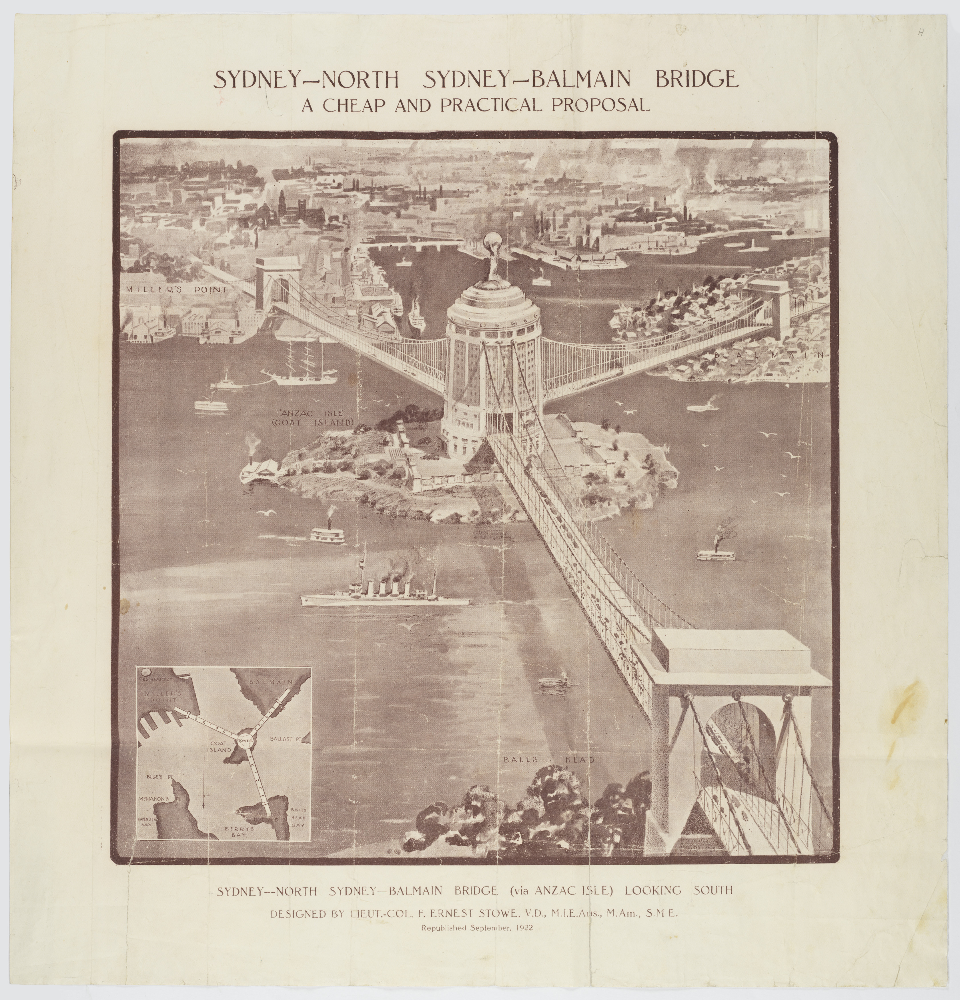
Series 02: Item 15, Cuttings mainly regarding suggestions for a second harbour bridge in Sydney, 1922

Source: Item 15: Cuttings Mainly regarding Suggestions for a Second Harbour Bridge in Sydney, 1922, 1922. Accessed July 28, 2023, https://digital.sl.nsw.gov.au/delivery/DeliveryManagerServlet?embedded=true&toolbar=false&dps_pid=IE6258874&_ga=2.23513913.2006621465.1690502948-563559362.1682639266&_gl=1*1f7f6uc*_ga*NTYzNTU5MzYyLjE2ODI2MzkyNjY.*_ga_CYHFMM592Q*MTY5MDUxMzU1NS42LjEuMTY5MDUxMzg2OC41NC4wLjA. 

In 1922, engineer Ernest Stowe proposed a three-way bridge to cross Sydney Harbour as "cheap" solution to building a harbour crossing. The three bridges would have linked the Sydney CBD with the North Shore and Balmain. It was envisioned that the bridges converge in a central tower on Goat Island. It was floated as a proposal alongside what became the Sydney Harbour Bridge.

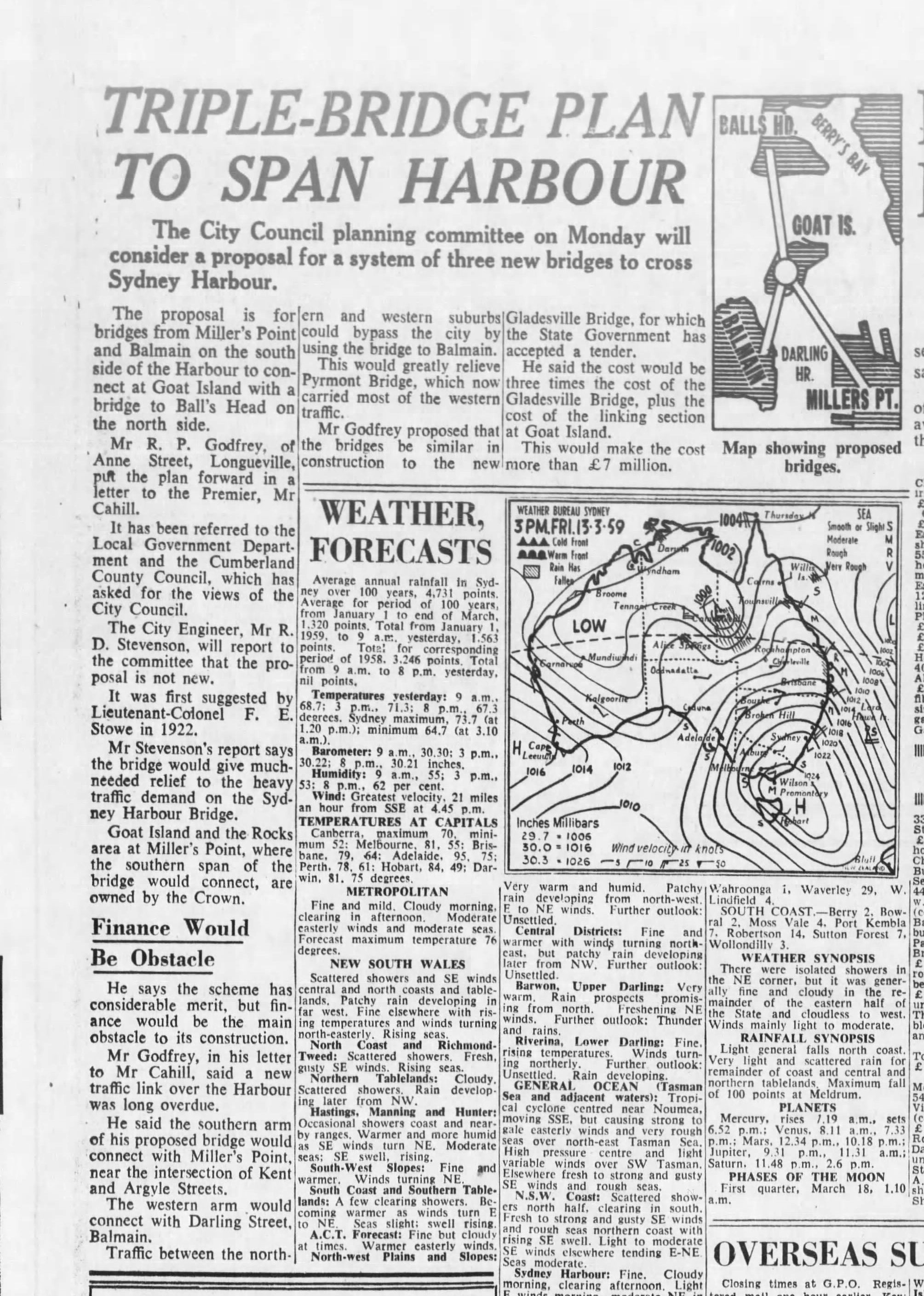
The proposal was floated in 1959 as a second harbour crossing by a Longueville resident who suggested that the bridge design be based on the Gladesville Bridge, which was proposed at the time. Below is an article from The Sydney Morning Herald in 1959.

Triple Bridge Span Plan March 14 1959 SMH 9 enlarged

Triple Bridge Span Plan March 14 1959 SMH 9 

Source: Anon. 1959. "Triple-Bridge Plan to Span Harbour". The Sydney Morning Herald, March 14: 9.

In 1981, a scaled-down proposal was proposed. The bridge scheme was one of several schemes which included tunnels under Sydney Harbour running predominantly through the eastern half of the Balmain Peninsula.

Second harbour crossing December 7 1981 SMH 3 
Source: Malley, J. "Under or over the Harbour: a choice". The Sydney Morning Herald, December 7: 1. 

Locals on both sides of the harbour mobilised, citing concerns over the loss of homes and safety risks associated with tunnels. This eventually led to the proposal being dropped, which ultimately led to the construction of the Sydney Harbour Tunnel.

  Balmain Harbour Crossing June 30 1982 SMH 1 enlarged
Source: Glasscott, J. 1982. "Balmain mobilised against the second crossing". The Sydney Morning Herald, June 30: 1.

Four decades later, the Western Harbour Tunnel fulfils the vision to allow those driving from the west to cross Sydney Harbour without driving through the Sydney CBD and need not use the Sydney Harbour Bridge.

Instead of heading in a northerly or northwest direction as envisioned by Stowe in 1922, the tunnel will send motorists in a north-easterly direction under Balmain and Birchgrove to Sydney Harbour, underneath the harbour and under Balls Head and North Sydney before connecting with the Warringah Expressway. 

Monday, 7 August 2023

VISIONS OF SYDNEY: Alternative Transport schemes for the Sydney Harbour Tunnel (1987)

Harbour Crossings February 24 1987 SMH 1 enlarged
Source: Coultan, M. 1987. "Bright ideas underwhelm Harbour Crossings Minister".  The Sydney Morning Herald, February 24: 1. 

In 1987, the NSW State Government announced that the Sydney Harbour Tunnel was to be built, running under Sydney Harbour from the Cahill Expressway at Macquarie Street to the Warringah Expressway at North Sydney.

Apart from alternative routes for the tunnel, other transport options were explored, including:

  1. Additional four lanes on the Sydney Harbour Bridge above the existing road deck.
  2. A rail tunnel between Wynyard and St Leonards
  3. A bridge running from Millers Point to Greenwich via Goat Island with a spur road to Balimain (proposals existed for decades dating to the 1920s)
  4. A tram tunnel from Paddington to Spit Junction via Bradleys Head and then running onto the Northern Beaches. 
Two of the four alternative ideas have evolved into reality, as reflected in current transport projects.

Rail tunnel between Wynyard and St Leonards

The 1987 vision involved the line integrated into the existing heavy rail network, but the Sydney Metro currently under construction from Chatswood to Sydenham has seen the construction of the first rail line underneath Sydney Harbour, following an alignment predominantly towards the east with stations at Crows Nest and Victoria Cross (North Sydney). However, the line runs west of the harbour bridge with stations at Barangaroo, Martin Place, Pitt Street and Central.

Suspension Bridge from Millers Point to Greenwich via Goat Island and Balmain Spur Road

This has evolved into the Western Harbour Tunnel running from the WestConnex at Rozelle, under Balmain, to connect with the Warringah Expressway at North Sydney north of Falcon Street. Completion is scheduled for 2028. The tunnel will enable traffic from the southern and western suburbs to bypass the Sydney CBD altogether. 

Related Entries

MILESTONE: Sydney Harbour Tunnel turns 25 (1992) 

VISIONS OF SYDNEY: Additional Sydney Harbour Bridge Roadways (1987)


Monday, 31 July 2023

VISIONS OF SYDNEY: Sydney CBD Light Rail Loop (2000)

CBD light rail loop August 14 2000 daily telegraph 15 enlarged
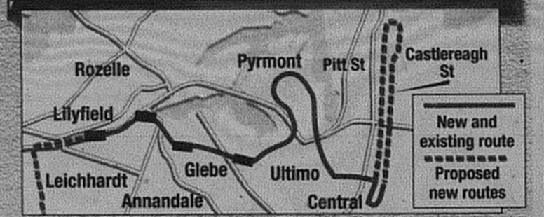
Above: The proposed Sydney CBD Light Rail Loop. Full Citation Below.

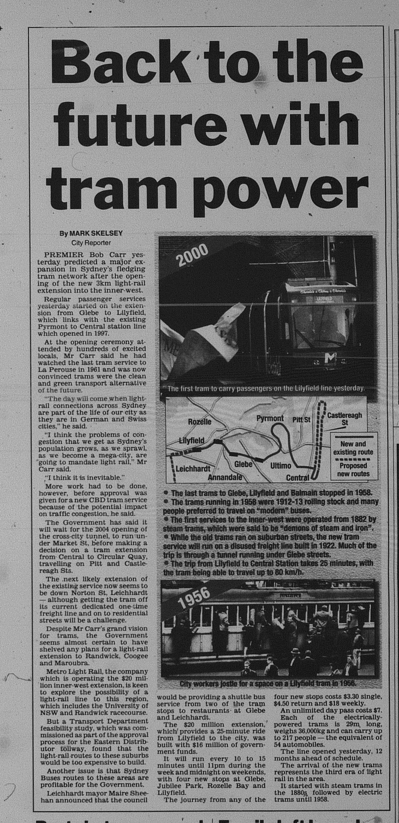
Back in 2000, Bob Carr predicted a major expansion of the Inner West Light Rail Line, which ran at the time from Central Station to Lilyfield. To coincide with the opening of the extension from Glebe to Lilyfield, the NSW government considered an expansion of the light rail network to include a Sydney CBD Loop running up Pitt and Castlereagh Streets from Central Station to Circular Quay. In the inner west, the light rail line would have been extended into Norton Street Leichhardt. Any expansion would wait until the opening of the Cross City Tunnel (proposed to open in 2004 at the time).
 
  CBD light rail loop August 14 2000 daily telegraph 15 

Source: Skelsey, M. 2000. "Back to the future with tram power". The Daily Telegraph, August 14: 15. 

The vision had its merits, especially the concept of a CBD loop which would have opened up for better integration of eastern suburbs services with inner west services, unlike the current network where eastern suburbs and inner west services operate independently of each other with no integration.

Monday, 24 July 2023

VISIONS OF SYDNEY: Sydney, 2001 as envisioned by Jeremy Bingham (1989)

For the next five weeks, I will run another Visions of Sydney series,  posting entries our planners or leaders had in mind for our city, whether it involved widespread redevelopment within the Sydney CBD and surrounds or new developments in our suburbs.

The first entry focuses on a vision by Lord Mayor Jeremy Bingham (1988-1991). In 1989 he revealed to The Daily Mirror what he wanted to see in Sydney by 2001.

  Sydney 2001 Vision March 23 1989 daily mirror 11

Firstly, he envisioned what has become the Cross City Tunnel. His plan was featured in a blog entry last year. It was not until 2005 that the tunnel became reality. It has not necessarily seen the removal of traffic from Bathurst Street and Park Street or William Street.

The Capitol Theatre was restored during the 1990's and his vision for wider footpaths has been fulfilled.in recent decades along with more garden settings i.e. plant boxes, though not all of it was undertaken by 2001.

Another vision was the tram revival. Unfortuantely, there was no tram service between Central and Circular Quay until 2019, but it was possible to travel from Darling Harbour to Central from 1997 which used most of the former goods line running along the rear of Darling Harbour and Pyrmont. 

However the electric bus loop and fast inner-city loop services were not fulfilled. 

Monday, 15 August 2022

VISIONS OF SYDNEY: Redeveloping the City Markets Precinct (1968)

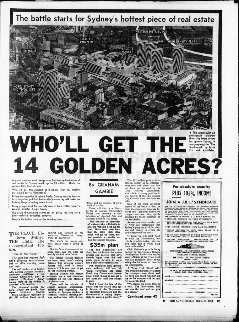
Haymarket Redevelopment September 8 1968 sun herald (1) enlargement 37Haymarket Redevelopment September 8 1968 sun herald (1)

Source: Gambie, G. 1968. "Who'll get the 14 golden acres?". The Sun Herald, September 8: 37 & 42. 

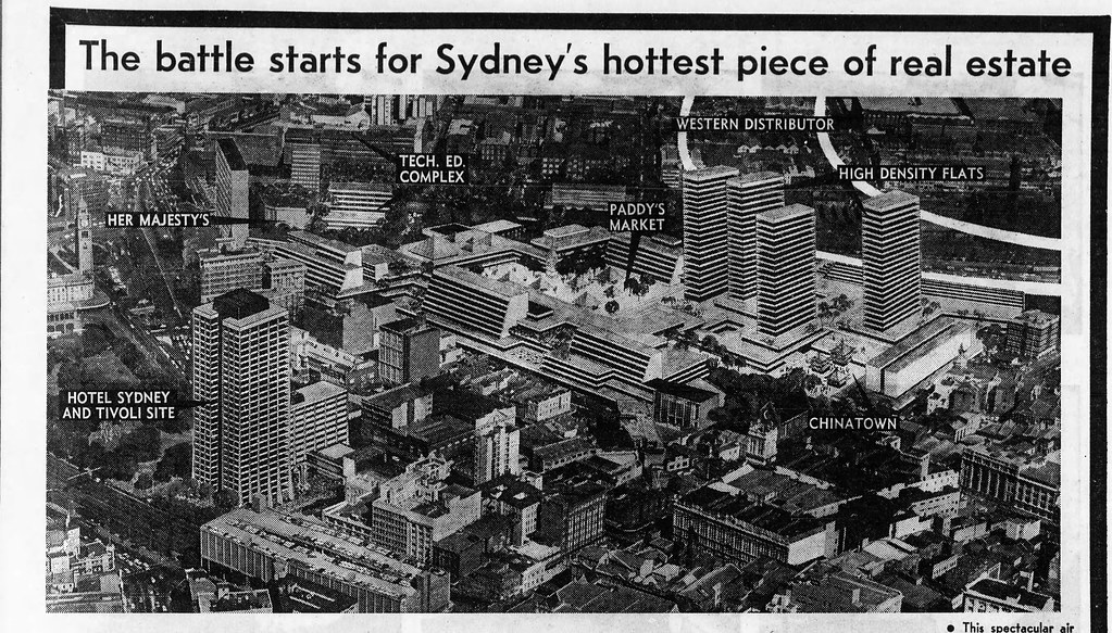
This is the last of my first set of entries in the Visions of Sydney series. In 1968, The Sun Herald asked Frank Fox & Associates to prepare a possible vision for the future of the City Markets site at Haymarket, which was relocated to Flemington. This was in response to State Government Proposals for an educational precinct to be created in the area, which was being opposed by the Civic Reform Association.

The fourteen acre area encompassed the current site of Paddys Markets, Darling Square (former site of the Sydney Entertainment Centre), Chinatown and areas encompassing Ultimo Road, Quay and Thomas Street's down to Railway Square.

The Civic Reform development plan encompassed the following:

  • Highrise apartment towers and carparks to be built alongside the Western Distributor (planned at the time to go through Glebe and the route is shown at the top right of image). The estimated population living in the area would be 10 000 people.
  • Opening up part of George Street to improve pedestrian access.
  • Retention of Paddys Markets.
Was this vision fufilled?
Not everything in a concept plan or vision will be fufilled. As the development at Barangaroo shows, it can be changed easily to accomadate changing needs or uses, which means there is a shift away from original plans or intentions.

The NSW State Government proceeded with its plans to develop an education precinct, which has evolved into the University of Technology, Sydney (attaining university status in 1988). Buildings encompassing the university have been built as far as Quay Street (Where the library is based). 44 000 students are currently enrolled. 

Paddy's Markets still trades at Haymarket, and is a "must-do" for visitors to Sydney. 

The High Density Flats would not appear until mid 2010's, after the closure of the Sydney Entertainment Centre (1983-2015) and the decision to incorporate it into a redeveloped Sydney Exhibition and Convention Centre Complex. The precinct is known as Darling Quarter.

Above: Darling Quarter fufilled a 1960's vision to turn Haymarket into a residential precinct. Photo taken by the Author (2021). 

One element not completed was the improved pedestrian access to George Street, though the underpass under Railway Square and the conversion of the former goods line into a walkway could be regarded as fufilling at least part of the vision.

The residential population of Haymarket according to the 2021 Census was approximately 8500., just short of the estimated 10 000.

As for the idea of the area becoming a centre of entertainment. Except for the Sydney Entertainment Centre (1983-2015), little was provided in terms of entertainment for Sydneysiders and visitors. Her Majestys Theatre was eventually demolished for an apartment block in the 2000's.


Monday, 8 August 2022

VISIONS OF SYDNEY: Additional Sydney Harbour Bridge Roadways (1987)

Sydney's Number One icon - The Sydney Harbour Bridge has even had own visions placed on it. I am not referring to the alternate designs or early proposals, but rather the existing structure itself.

Since opening in 1932, it has had to shoulder the burden of carrying vehicles from north to south and vice versa. For sixty years, it was the only direct crossing for vehicles across Sydney Harbour. The Sydney Harbour Tunnel in 1992 provided Sydney motorists with a second crossing. It did for a few years take the pressure off the bridge itself. 

It is anticipated by 2027, a third road crossing, the Western Harbour Tunnel will provide another bypass road for Sydney's CBD. The tunnel will connect the WestConnex with the Warringah Expressway, running under the Balmain Peninsula and North Sydney.

Building a harbour crossing is not cheap. The Western Harbour Tunnel will cost at least $7 billion to build (likely to be higher) and the Sydney Harbour Tunnel cost $560 million to build.

Proposals or visions for additional crossings has lasted for decades. 

To avoid construction of new crossings, some have proposed boosting the capacity of the briudge itself through construction of additional road decks, either above or below the existing road deck.

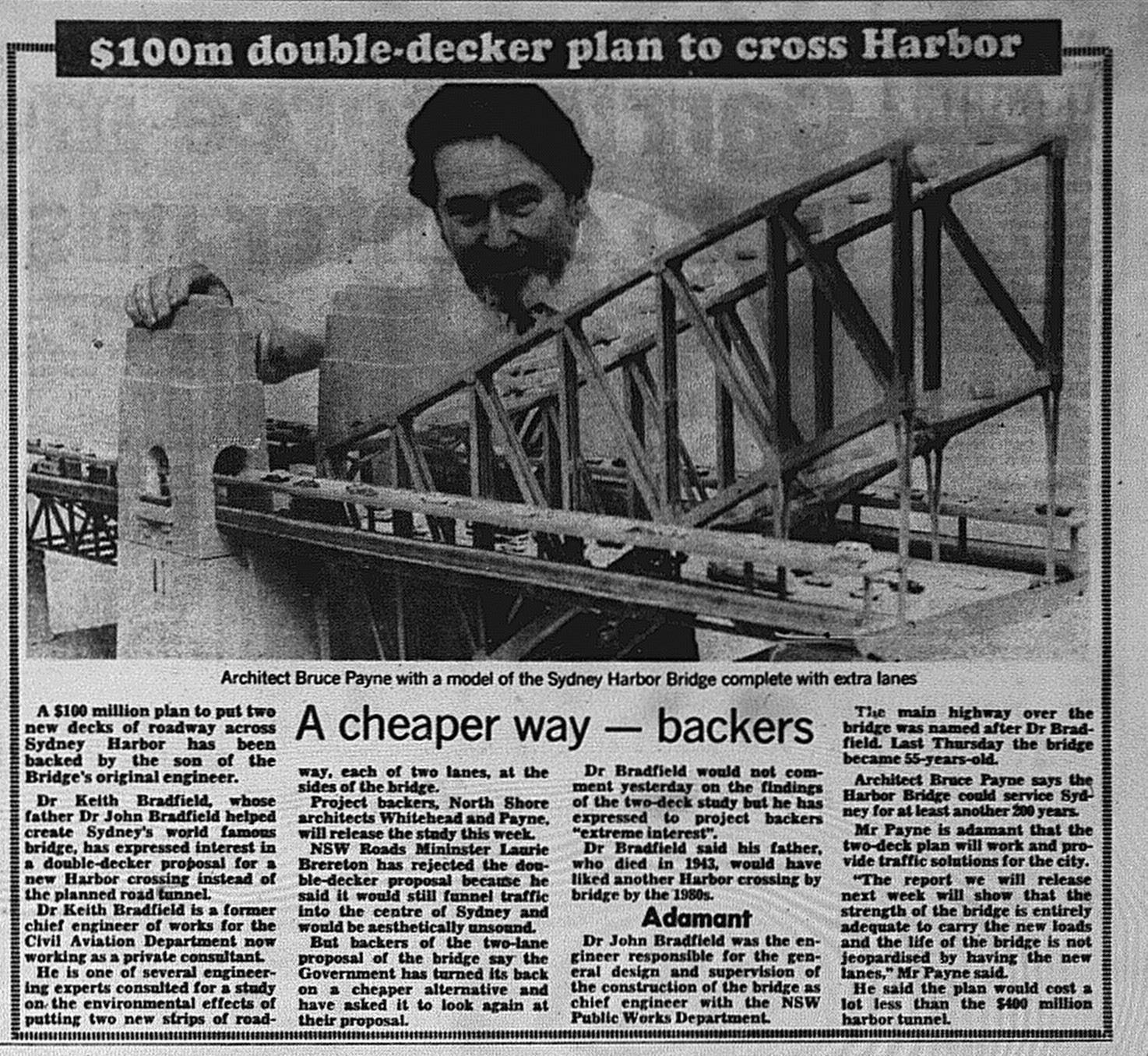
In 1987, Architect Bruce Payne of Whitehead and Payne along with the support of Dr Keith Bradfield (son of Dr. John Bradfield), unveiled a proposal to build two additional strips of lanes above the existing lanes instead of building the Sydney Harbour Tunnel.  

The two strips would carry an additional four lanes of traffic (combined) with two lanes in each direction.

Sydney Harbour Bridge Double decker March 23 1987 daily telegraph 13

Source: Anon. 1987. "$100m double-decker plan to cross Harbor". The Daily Telegraph, March 32:13. 

It was the not the first proposal. In 2005, "Project Star" proposed that a second deck would be built in the undercarriage of the bridge allowing the bridge to carry an additional four lanes of traffic plus an additional two rail tracks.

In 2010, The Sun Herald, reported on a proposal by transport experts to build a second rail deck underneath the existing road deck to accomodate a new heavy rail line running from St Leonards to the city, following largely what is now the Sydney CBD Metro with new platforms at Wynyard instead of a new station at Barangaroo.  

Monday, 25 July 2022

VISIONS OF SYDNEY: Sydney CBD Road Tunnels (1990)

Cross City Tunnel October 5 1990 daily mirror 17

Source: Anon. 1990. "Tunnel solution to city traffic jams". The Daily Mirror, October 5: 17. 

This is the second entry in our first Visions of Sydney series. In 1990, Deputy Lord Mayor Ross Bonthorne, proposed a network of underground road tunnels running through the Sydney CBD to address traffic congestion at street level.

The network proposed four tunnels. Motorists could use the tunnels to access carparks or delivery zones.

One tunnel would run under Park Street. This became reality through the Cross City Tunnel, completed in 2005. However the Cross City Tunnel was a designated motorway to provide a bypass underneath the Sydney CBD to connect the eastern and western suburbs of the city.

The second tunnel would run underneath Goulburn Street to serve the southern CBD.

The third road tunnel was to run east-west near Martin Place and would connect with the Cahill Expressway. Three possible routes were proposed.

The fourth tunnel running underneath Pitt Street would connect the three east-west tunnels. 

Next week, we will continue with the next entry in the series.