Showing posts with label urban planning. Show all posts

Monday, 7 September 2026

1987: Sydney Regional Centres Feature

Chatswood August 1 1987 daily telegraph 20
Source: Pelly, M. 1987. "Suburbs that spawn cities within a city". The Daily Telegraph, August 1: 20. 


The Daily Telegraph in 1987 published a feature report on commercial development in three Sydney regional centres - Bondi Junction, Chatswood and Parramatta. The 1980s saw a boom in office development in these centres, already well established due to public transport (including being located on major rail lines), and also acting as established retail and entertainment centres. 

If we fast forward four decades, Parramatta has made the most progress. Even in the 1980s, it was a major growth centre and continues to be so. It is Sydney's Second Central Business District (CBD) and planning guidelines now allow development in central Parramatta to be treated as if it were being done in central Sydney.  Under the planning blueprint - The Sydney Plan (2018), Parramatta is regarded as one of three metropolises within Greater Sydney, alongside the Sydney CBD and Bradfield. Major skyscrapers that one would normally find in Sydney's CBD have made their presence felt. The tallest tower is the 225 metre/57 storey 6 & 8 Parramatta Square.

High-rise development continued into the 1990s for Bondi Junction and Chatswood, but the decade saw greater emphasis on residential towers, and both also continued to evolve as retail centres. 

Westfield expanded their retail complexes in both centres. The redevelopment of Westfield Bondi Junction (incorporating Bondi Junction Plaza, Carousel and the Grace Bros site) in the early 2000's into a single retail complex would make it a flagship centre for the Westfield Group upon completion in 2004. This cemented Bondi Junction as a retail destination for the Eastern Suburbs, attracting luxury labels from Double Bay or Oxford Street, Paddington. 

Chatswood has benefited from the construction of the Metro North West, City and Bankstown Line and its predecessor Epping-Chatswood Rail Line. This has opened up access to those at North Ryde and North West and, in late 2026, Bankstown. 

The Metro West Line (Hunter Street, City to Westmead) will provide those travelling between Parramatta and the Sydney CBD with a faster service, relieving the existing T1 Western Line when completed in 2032. Major towers are planned for the blocks located directly above the proposed Parramatta Metro Station and will be easily connected to existing Light Rail and heavy rail lines. 


Monday, 21 July 2025

VISIONS OF SYDNEY: Widening George Street Footpaths (1986)

George Street Pedestrianisation December 9 1986 Daily Telegraph 3

Source: Nicholson, L. & Mulligan, M. 1986. "City to open up for pedestrian network" (1986). The Daily Telegraph, December 9: 3.

Visions of Sydney is back for the next five weeks, as I explore some of the visions that never quite became a reality in Sydney, or were an early scheme or proposal for an eventual project or scheme. This focuses on transport and public spaces, as Never Built Sydney encompasses buildings and architecture.

In this entry are two newspaper clippings from December 1986, when the NSW State Government proposed widening footpaths on George Street by removing one lane in each direction from use by vehicular traffic. It was even considered to convert George Street to one-way traffic.

Three decades later, the construction of the Sydney CBD Light Rail project would see the street converted into a pedestrian boulevard, initially from Bathurst Street to Hunter Street, before being extended to cover George Street from Rawson Square to Bridge Street.

Pedestrians would eventually claim control of George Street; however, if the original scheme had been implemented and nothing else had changed, it would have paved the way for George Street as it exists today. The outcome we see would still have eventuated.

Sydney CBD Pedestrian Plan December 9 1986 SMH 6

Source: Glascott, J. 1986. "Unsworth promises pedestrians a fair go in new city plan." The Sydney Morning Herald, December 9: 6.

Monday, 11 April 2022

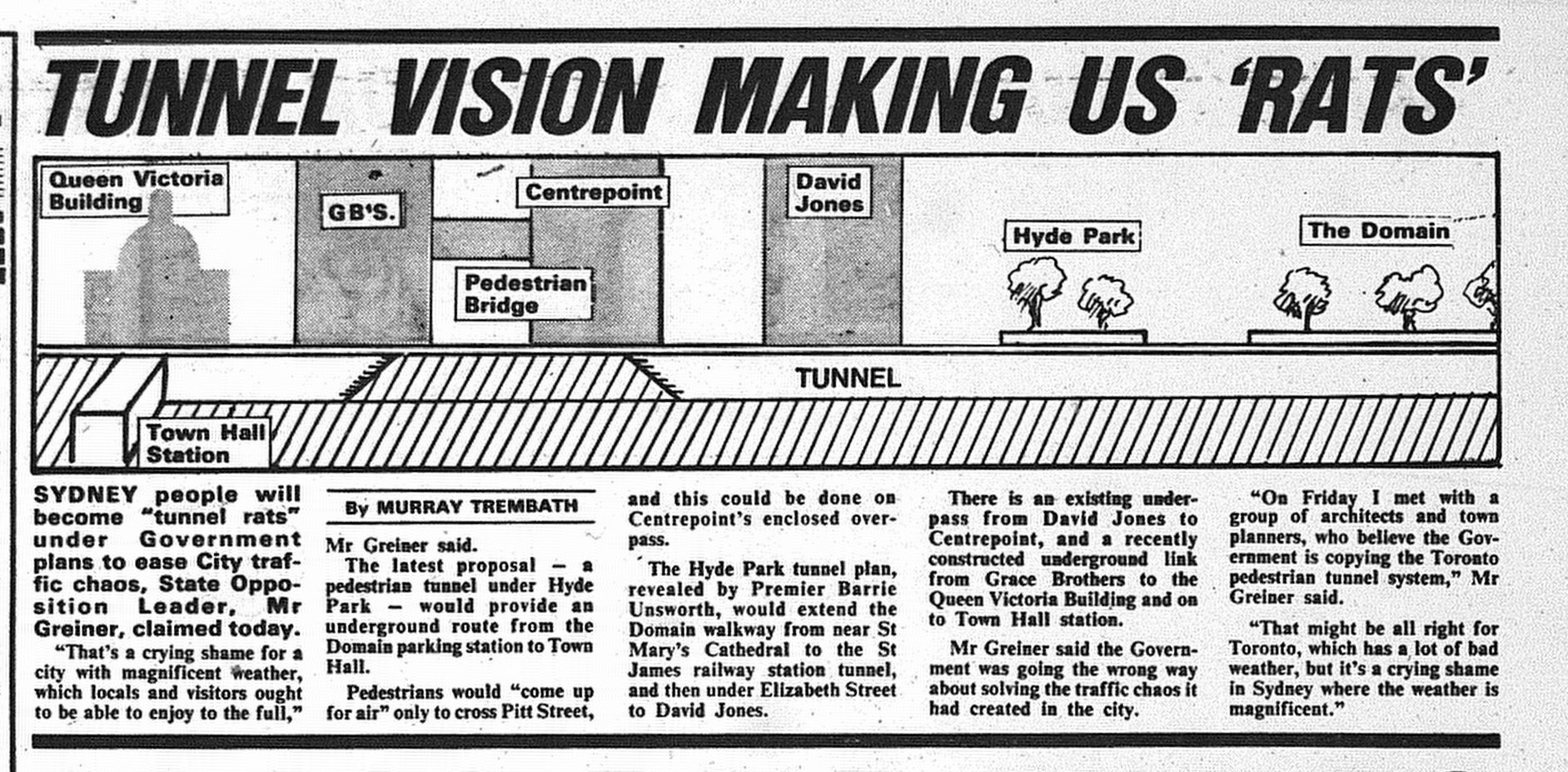
1987: Tunnel vision making us 'rats' (The Sun Article)

In 2016, I posted the entry Underground Sydney which focused on the development of an underground network of pedestrian walkways to connect retail complexes in central Sydney with major rail stations such as Town Hall. 

   Sydney CBD Pedestrian Tunnel Network June 22 1987 The Sun 2

Source: Trembath, M. 1987. "Tunnel Vision Making Us 'Rats'". The Sun, June 22:2. 

While this plan was largely fufilled, the underground walkway in Hyde Park did not eventuate to allow for a person to walk unimpeded from The Domain carpark to Town Hall Railway Station.

NSW Opposition Leader Nick Greiner was concerned that people would become "tunnel rats" and lose the opportunity to enjoy the "magnificent weather". However, I think anyone who would use the network of pedestrian tunnels, does so out of convenience. I do for instance. 

As I pointed out in 2016, any negative impact would be on foot traffic at street level, though the opening of the Sydney CBD light rail line in 2019 has resulted in the closure of George Street to private vehicles and buses from Bathurst to Hunter Street allowing for pedestrians to utilise the street. George Street was already experincing a revival prior to its opening as high end retailers begun to make their present felt at street level. 

Monday, 26 October 2020

1982: Life in the Park Regis

In 1982, the Park Regis was 14 years old and The Sydney Morning Herald interviewed some of its residents, all of whom were original buyers in the tower.

It would be interesting to compare the residents of 1982 with that of 2020. I am curious if any of the original residents still reside in the tower or even their descendants. 

Four decades ago, living in central Sydney was still a novelty.


Source: Wyndham, S. 1982. "Charles Weil says he'll take the Park Regis". The Sydney Morning Herald, September 18: 27.

Monday, 12 October 2020

1989: Urban Development around Badgerys Creek Airport


Source: Morris, L. 1990. "Oran Park to go for new city". The Daily Telegraph, September 2: page unknown.

Trawling through my clippings, I came across an article from September 1989 published in The Daily Telegraph. 

The State Government was planning a "mini-city", the size of Canberra to be built in a corridor incorporating the proposed Badgerys Creek Airport. This was seen as a response to the land shortage gripping Sydney (like today). 

Oran Park Raceway would be closed with housing to replace the former race track.  This occurred in 2010 and housing has since appeared.

With construction of the new airport underway three decades later, planning still continues. The focus has shifted towards commercial and industrial development to create a Western Sydney Aerotropolis. The long term goal is to create 200 000 jobs within the precinct which will follow the 1989 corridor. That is nearly two thirds of the number that commute into Central Sydney each day to work.

In 1989, they were unlikely to have considered high rise residential development, whereas three decades later it is being seriously considered.

Monday, 28 September 2020

1986: Overshadowing of city streets

With building height limits in central Sydney becoming increasingly relaxed to allow taller buildings, there will be the ongoing debate about overshadowing of city streets.

At present, the maximum building height is 310 metres (height of Sydney Tower).


Source: Glascott, J. 1986. "Tower blocks putting city in the shade". The Sydney Morning Herald, April 14: 3. 

It has been occurring for decades as this article from The Sydney Morning Herald in 1986 shows. There was concern that a proposed highrise development in Bridge Street (1 Bridge Street) would cause greater shadowing of Australia Square in addition to existing towers including the National Australia Bank building, QANTAS Centre and Grosvenor Place (under construction). While not specified, this would become a major office tower by decades end, shifting towards Bond Street. 

Above: The proposed Bond Street office tower (1988). Full citation below.

Source: Chancellor, J. 1988. "Bond St tower go-ahead expected". The Sydney Morning Herald, November 1: 32.

The tower itself did not eventuate with a smaller building (Mantra Hotel) built in the late 1990's rising to 18 levels or 60 metres above street level. 

In 1986, the Marriott Hotel and Gateway Tower (proposed and later built) raised concerns about overshadowing in Macquarie Place. I ask myself if the shadowing of the space is that bad? It feels like it gets a good amount of sunlight when I walk through during daylight hours. Fortunately low rise buildings dominate the eastern side Loftus Street, allowing for sunlight to filter through.

I went for a walk during the "lunch" hour recently to get an idea of sunlight filtering into the squares. All photos were taken by yours truely. 

Macquarie Place


Australia Square

I think the 2 Bond Street Tower would have blocked the sun filtering into the square.


The debate about shadowing of city streets and parks arose a year later with the proposed Skytower/Park Plaza tower in Park Street.

A decade later (1995), height limits were maximised at 235 metres to allow for sunlight to filter into city streets, public areas and parks while current heights were adopted in 2016.

Thank you to Richard Braddish of Sydney City Council for supplying additional information.


Monday, 31 August 2020

1989: Gateway Tower as Sydney's "last" glass building

The Sydney Morning Herald predicted in 1989 that the Gateway Tower would be the last glass building built in Central Sydney based around a review of planning across the Central Business District.


Source: Quddington, P. "Why this may be Sydney's last glass tower". The Sydney Morning Herald, March 8: 1.

Three decades later, if standing at Kirribilli or on the steps of the Sydney Opera House, turn your eyes to the right of the Gateway Tower and one will notice an even taller tower rising and it has a glass facade. Crown Sydney. 

Monday, 3 August 2020

SYDNEY SKYSCRAPERS: The conception of Aurora Place (1996)

My favourite skyscraper in Sydney is Aurora Place. The tower in Phillip Street rises 41 storeys to a height of 219 metres (spire). I regard it as the skyscraper that most reflects Sydney - its architect Renzo Piano wanted the tower to "talk" to the Sydney Opera House.

The Sydney Morning Herald in 1996 published a feature behind his idea.


Source: Susskind, A. 1996. "A talking tower is Renzo's gift to Sydney". The Sydney Morning Herald, November 9: 1 & 3. 

Ever noticed how the fin atop the tower reflects the Opera House sails?

Photo taken by the Author (2011)

Two decades later, Renzo Piano is again making his mark in Sydney as three major highrise apartment towers at Barangaroo South rise. The penthouse atop One Sydney Harbour has sold for $140 million, making it the most expensive property in Australia.

Piano has stuck to a more functional design for his Barangaroo towers as the emphasis architecturally must be on the Crown Resort located right next to his towers. 

Monday, 4 May 2020

2001: Meriton Apartments failed attempt to redraw the boundaries of Moore Park

Moore Park is not just a park. It even has its own suburb and postcode (2021). Moore Park also includes the former Sydney Showgrounds Site/Entertainment Quarter, Sydney Cricket Ground and the Sydney Football Stadium.

In 2001, Meriton Apartments was in the early stages of its redevelopment of the ACI Factory Site at Waterloo and asked South Sydney Council to alter the boundary of Moore Park to include the development. South Sydney council refused.


Source: Skelsey, M. 2001. "Estate meets its Waterloo". The Daily Telegraph, March 14: 26.

Monday, 2 December 2019

NEVER BUILT SYDNEY: Alternative scheme for the Westpac Place site (1999)


Source: Skelsey, M. "City block bulldozed for units". The Daily Telegraph, March 10: 5.

The block bounded by Kent, Erskine, Napoleon and Sussex Streets (KENS) is home to Westpac Place, which is regarded as one of Sydney's largest buildings in terms of office space (also in terms of space per floor).

Twenty years ago, there was a scheme for the site that involved the construction of three 80 metre apartment towers which caused tremendous controversy for Sydney City Council. The council refused to approve the scheme because the towers were too close to each other, but were willing to approve the scheme if one tower was removed.

Developer Multistar took this to the Land and Environment Court and won approval.

Even the tower we see today had its difficulties in gaining approval - bulk, height and wind tunnel concerns were problems, but construction began in 2003 and was officially opened in 2006.

Fast forward a decade and a half and the Barangaroo development makes the building appear small.


Source: Skelsey, M. 2001. CBD tower's glaring faults: Authority warns of problems. The Daily Telegraph, July 4: 14.

Monday, 19 August 2019

1972: The suicide of a city (Feature Article)

The Daily Telegraph published a feature article in 1972.  Evan Whitton wrote an article about the failure of planning authorities to adhere to the 1948 Cumberland Plan.

1972 was nearly 25 years since the Cumberland Plan had come into existence, with a focus on creating a green belt on what was then the outer boundaries of Sydney which would separate the city from the outer regions including Campbelltown and Penrith.

There would be wedges of open space among st the suburbs of Sydney.

Under the plan, the population of Sydney was to be contained at 3 million people. During the 1970's Sydney's population reached 3 million.

The Cumberland Plan never came into effect.

Note that it was projected in 1968, Sydney would have a population of 5 million by the year 2000. Sydney would only reach 4 million by 2000 and 15 years later hit 5 million.

The article was published on December 13, 1972.


Monday, 29 July 2019

1987: Skytower, city development and building height limits

As you may have noticed, I have taken a break from posting as I was recently on holidays in Melbourne during the school holiday break and didn't prepare any postings for the past week

In this past week, heights of city buildings have been discussed as The Daily Telegraph published visions of what Sydney's Central Business District and regional centres could appear in as little as two decades from now.

It envisions that Sydney will need to build towers double the height of the existing tallest buildings in the city to accommodate for future population growth and demand for commercial space.

This will be a huge subject of discussion because building significantly taller buildings would actually preserve existing low density neighbourhoods, as development would become more concentrated in fewer parts of the city. Restricting height limits could create more dilemmas and this would meaning zoning more low rise areas for high rise.

If we went back more than thirty years, the NSW Government wanted to restrict Sydney building height limits in 1987. Barrie Unsworth was premier and Bob Carr was the environment and planning minister. He was concerned that developers wanted buildings in excess of what was permitted but at the same time was also concerned about overshadowing of public parks and civic spaces.

One development that concerned him was Alan Bond's proposed Skytower at 2 Park street which I covered last year.

Below is an article from The Daily Mirror as published in November 1987.


Source: Farr, M. 1987. "Carr Cuts Skyline Down to Size for New Image". The Daily Mirror, November 3: 14-15.

Building height limits were based on the Sydney Strategic Plan of 1971, which was not as rigid as current policies are today.

In early 1995, building height limits for central Sydney were set to prevent overshadowing over public spaces and parks at a maximum of 235 metres. I have in a previous entry posted the article. Bob Carr did not impose the limit as at the time, as he was NSW Opposition Leader. He would be elected weeks after the plans were released. His idea certainly proved feasible at the time.

Monday, 4 March 2019

2000: Bob Carr & High rise Design

Below is a 2001 article from The Daily Telegraph, focusing on Bob Carr's proposal to improve the design of apartment blocks in Sydney.

The article does not mention it, but it is believed that Bob Carr was unimpressed with the architectural designs of highrise residential blocks in his electorate of Maroubra and wanted standards raised.

Some residential buildings were even designed by non-architects.


Source: Skelsey, M. "Ban on shoeboxes: Changes to stop 'lousy' unit plans". The Daily Telegraph, October 21: 7. 

This led to the passing of legislation in 2002. Under Section 65 of the State Environmental Planning Policy - Design Quality of Residential Flat Development. It meant that a registered architect could only design a residential building.

As we move towards two decades since the legislation has passed, and the results to the average person would appear to be mixed. Broadly speaking, there has been a general improvement in the terms of the architectural design of residential buildings in Sydney, particularly in the Sydney CBD and inner suburbs. As for suburban Sydney, it varies. In some suburbs, I have noticed that highrise buildings built in the past decade architecturally are more appealing than those built in the 2000s. I look at Rockdale for instance and have noticed an increase in the architectural standard of some of the unit blocks.

Even with this law, there are unit blocks that architecturally are not appealing to the eye, and tend to be in the outer suburbs, where the focus is on profit over quality. I think councils in suburbs further out may need to work on improving standards for architectural design.

There were critics that argue that architectural quality means higher house prices. I will concede that this is true, but sometimes we need to consider this cost in terms of providing quality streetscapes in which the buildings will shape, along with making a home as livable as it can be.


Monday, 4 December 2017

Visions of the Future: Sydney Skyline, 1975 (1972)

While the illustrations may not be the best, this vision of Sydney's skyline in 1975 was published in the October 3, 1972 edition of The Daily Telegraph.


While the buildings featured were generally built (bar two or three), they were completed well after 1975. I have listed the completion dates of some of the buildings below:

MLC Tower (11) - 1977
Sydney Tower (7) - 1981
AMP Centre (18) - 1976
Law Courts Building (16) - 1977
Qantas Centre (5) - 1982
Gateway Tower (14) - 1989

Below is the accompanying feature article.


Monday, 4 September 2017

1967: When Collaroy's unit blocks faced collapse


Above: The Sydney Morning Herald published an aerial shot of the storm swells threatening properties at Collaroy on the front page of the September 7, 1967 edition of the paper.


Source: Anon. 1967. "Beaches Ruined: Battle to save esplanade, homes". The Sun, September 5, 3.

For many of us, we remember the devastation at Collaroy Beach last year when 10 homes faced collapse at Collaroy when the beachfront was eroded heavily during a storm.

Fifty years ago, homes and unit blocks along the beachfront were threatened with collapse when similar conditions affected the beach over several weeks in August and September of 1967

The worst affected dwellings were just south of Ramsay Street. This included the Flightdeck and Shipmates apartment buildings. The foundations were exposed leading to the risk of collapse.
One nearby home nearly fell into the sea. Fifty years and many storms later, its still standing.


Source: Anon. 1967. "Fight to Save Homes". The Daily Mirror, September 6, 5.

The battle against nature was won


Source: Anon. 1967. "The Beach Battle Won: Rock Wall Holds". The Sun, September 7, 2.

People were being warned back then about the loss of beachfront properties which could have occurred within a lifetime e.g. fifty years. The beachfront homes are still standing today. However, with natural processes, the Collaroy area will eventually succumb to the sea. 


Source: Harrison, T. 1967. "Professor says... All this Will Go! But don't panic, it may take centuries". The Sun, September 7, 4. 

The properties in the affected area in 1967 eventually saw a rock seawall placed in front of their dwellings. This has prevented further erosion and any loss of property. However, it stopped at Ramsay Street. The worst affected properties in last years super storm were located to the immediate north of the street.

Is it worth spending a fortune on beachfront property? Some are prepared to fork out the money, but they do so knowing that the next storm could see their home washed out to sea.

Fortuantely, we have learnt in Sydney and NSW that building right on the foredune of a beach is not good in protecting a beach, but also the damage it can cause to buildings in the event of erosion. Highrise buildings are no longer permitted in beachfront areas that are vulnerable to beach erosion along with restrictions in housing development?

But what about homes built before the laws? One can still build, but bear the risks that the next major storm can bring.


Monday, 30 January 2017

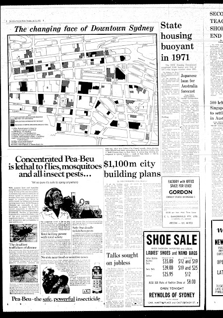
Remember this: The changing face of downtown Sydney (1972)

This is the last entry of our "Remember this" series. We are in the midst of a huge building boom in downtown Sydney. In the early 1970s,  we saw a similar transformation take place though it would have been even more dramatic than the boom we are experiencing today.


Source: Frykberg, I. 1972. "The changing face of Downtown Sydney". The Sydney Morning Herald, January 13: 2. 

Monday, 5 September 2016

1974: The battle to save beachfront homes at Bilgola Beach

I was motivated to do this entry after what occurred back along the beachfront at Collaroy in June. Ten homes fronting the beach were threatened with collapse after heavy swells caused by an East Coast Low eroded the beachfront.

The East Coast Low of May 25-26 1974 (known as the Sygna Storm) is regarded as the most ferocious storm to ever strike Sydney.  The city was pounded by heavy rain, strong winds (up to165km/h) and record swells of nine metres along the city's coastline. the worst damage was reported on the city's beaches, which were heavily eroded. The following fortnight saw another two East Coast Lows hit the city, which only worsened erosion.

The worst hit area was at Bilgola Beach, where homes in June 1974 were threatened with collapse which was quite similar to what happened at Collaroy this year. Below is the front page of the  June 5, 1974, edition of The Manly Daily.


A seawall was built (presently under the dunes) to protect the homes. Fortunately, they were saved as this front page clipping from The Manly Daily of June 12, 1974, shows below.


 An almost intact pool fell into the sea, just like at Collaroy earlier this year.


It is inevitable that the homes on the beachfront will be threatened again in the future as natural processes reshape the beachfront and retreat inland. There is no date for when it will happen, but luckily locals have not had to deal with the threat of losing their beachfront homes since that storm.


Monday, 25 July 2016

1998: Bruno Grollo & Sydney

This week, I thought I'd share a feature report on Bruno Grollo, that was written by Mark Skelsey of The Daily Telegraph in late 1998. Grollo was the head of Grollo Constructions (now Grocon).

At the time, he was in Sydney to attend the final concrete pour of their first project in Sydney - 1 Martin Place. It included the restoration of the famous GPO Building. Behind the stone facade, would rise a 25 level office and hotel complex. 1 Martin Place would open to the public less than a year later.


Source: Skelsey, M. 1998. "Grollo has high hopes for Sydney". The Daily Telegraph, December 11: 35

Grollo was keen to see if Sydney could end up with its own Grollo Tower, which believe it or not was at the same time he had won approval to build his 120 level, 560 metre tower in Melbourne which at the time would have been the world's tallest skyscraper.

The article mentions that Sydney's height limits (Capped at 235 metres) was due to the need to protect the views from Sydney Tower, which from what I am aware of, is not correct. From my understanding, Sydney's current height limits have stemmed from the need to allow sunlight to penetrate into city streets, public spaces and parklands.

This article from 1995 explains why:


Source: Skelsey, M. 1995. "The sky's not the limit: New city plans could reign in high-rise boom ". The Daily Telegraph Mirror, February 3: 14.

Earlier this month, Sydney City Council announced that it is proposing to increase the city's height limit from 235 metres to a maximum 310 metres., Already, there are proposals that are testing the waters for taller towers in central Sydney, with negotiations currently taking place between developers and the council. One proposal is for a 248 metre office tower at Circular Quay and a 260 metre apartment tower above the Event Cinemas complex in George Street.

Monday, 28 March 2016

1987: Underground Sydney

When the redevelopment of the Queen Victoria Building into a shopping complex was completed in 1986, it would change Sydney retailing. Sydney ended up with a major shopping destination in the city centre, but the focus is on something else that might appear minor on paper but did have major ramifications for retailing in central Sydney. Its underground level would link the retail around Town Hall with the soon to be completed Pitt Street Mall.


Source: Roberts, R. 1987. "Underground Sydney: From Town Hall to Hyde Park, it's now possible to walk without ever seeing daylight". The Daily Telegraph, July 6: 10. 

The report claims that it is possible to walk from Town Hall to Elizabeth Street at Hyde Park without seeing daylight. This is not possible, even today. You would have to cross Pitt Street (now a mall) to reach Centrepoint from Grace Bros, even if it meant using the sky bridge. It is possible however to do the trek without physically going outside. 

As for the move towards underground retailing, it had been in the council's agenda for at least two decades beforehand. It was not until the 1980s when this had begun to take off. It was the redevelopment of the Queen Victoria Building that would cement underground retailing in Sydney.

The redevelopment of Centrepoint into Westfield Sydney in 2010 then made it possible to walk to Martin Place without having to cross any streets. Links were built into the Glasshouse retail complex which was linked by sky bridge to the MLC Centre and Martin Place train station. I do remember though pre-redevelopment that it could be done through the former Imperial Arcade and Skygarden. This required going through Lincraft in the Imperial Arcade to make a direct walk to Martin Place possible.

Not long after the QVB redevelopment, the retail podium of 586 George Street also included a direct link between the George Street cinema strip and Town Hall Station. There were plans even to link Regent Place to Town Hall in plans but never happened. Even the proposals for Fraser Residences examined it but did not proceed A lost opportunity for retailers there. In 2000, The Galeries Victoria also joined the underground retail network helped by its location almost directly above Town Hall Station.

While the underground retail complexes and walkways have been of benefit to city retailing, its main weakness is that it takes away foot traffic at street level. Sydney streets are not teeming with people as say Melbourne which largely focuses on retailing at street level and drawing on its network of laneways and historic arcades to lure shoppers.

It has been fifteen years since the Galeries Victoria was built and since then, there have been no new major retail developments built below street level in Sydney's CBD. It has shifted back towards street level. With the success of the Pitt Street Mall in attracting city shoppers, the city retailing precinct has expanded east into Castlereagh and Elizabeth Streets, north towards Martin Place and west onto George Street which over the past decade has attracted major retailers, spearheaded by Apple who opened a flagship store at the corner of George Street and King Street in 2008. UK clothing giant Topshop opened in the former Gowings Building in 2013. The new light rail line snaking its way down George Street could unleash further growth in street level retailing in central Sydney with traffic forced off the city's main throughfare, creating a shopping environment that will be safe for visitors to our city. 

Monday, 7 March 2016

1973: Sydney Harbour development

In 1973, The Daily Telegraph decided to explore some possible visions for Sydney's future based on news events of that time. For decades now, State and Commonwealth land have gradually been handed back to the public and with each handover, there is the debate of what to do.

North Head, for instance, was envisioned as being a park with tree-lined roads but there would be a lookout tower and restaurant.

The vision that could have probably been the most controversial would have been the plan to build a massive marina at Balmoral. This would also include demolition of the famous baths. Balmoral is noted for its long beach, quiet waters and picturesque setting which attracts people from far and wide, so a marina may have not been the right move for the suburb. The idea for a large marina stemmed from the concerns about access to the harbour and mooring space.

It was proposed that other sites around the harbour would also house marinas, though many of those sites have not experienced marina development in any capacity.